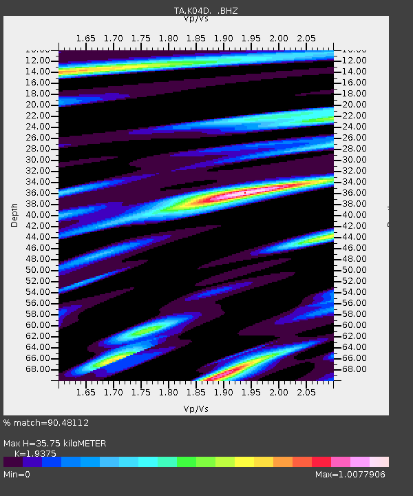
K04D Chiloquin, OR, USA - Earthquake Result Viewer
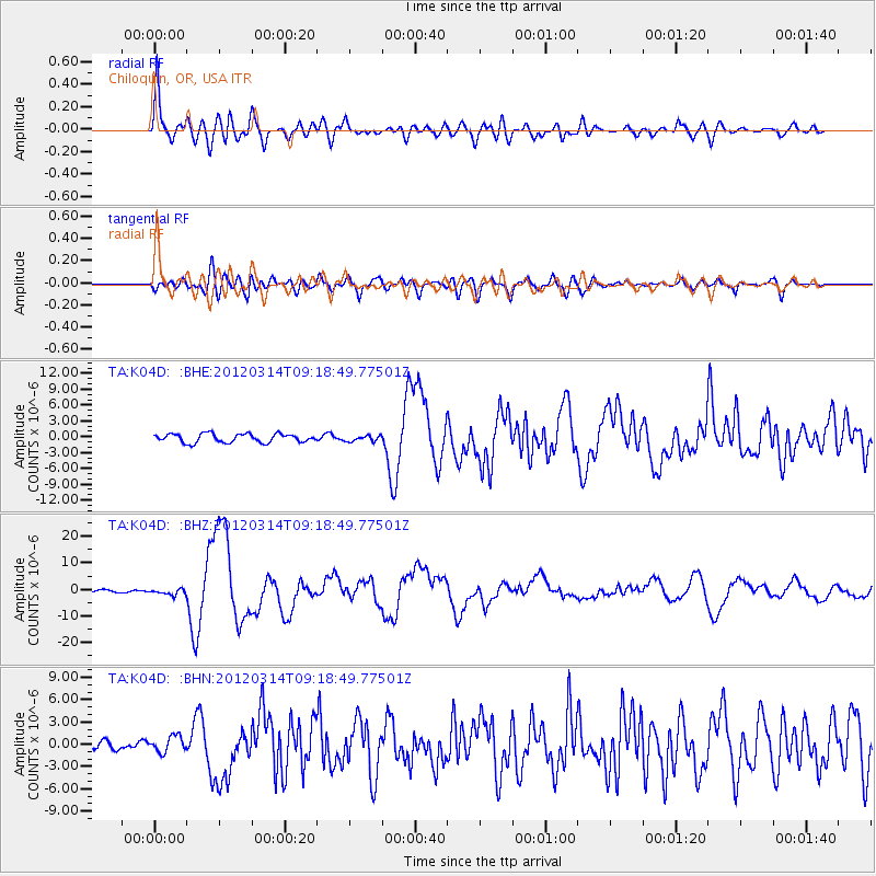
Earthquake location: Off East Coast Of Honshu, Japan
Earthquake latitude/longitude: 40.9/144.9
Earthquake time(UTC): 2012/03/14 (074) 09:08:35 GMT
Earthquake Depth: 12 km
Earthquake Magnitude: 6.7 MB, 6.9 MS, 6.9 MW, 7.0 MW
Earthquake Catalog/Contributor: WHDF/NEIC
Network: TA USArray Transportable Network (new EarthScope stations)
Station: K04D Chiloquin, OR, USA
Lat/Lon: 42.62 N/121.75 W
Elevation: 1315 m
Distance: 65.9 deg
Az: 53.8 deg
Baz: 304.01 deg
Ray Param: 0.057939135
Estimated Moho Depth: 35.75 km
Estimated Crust Vp/Vs: 1.94
Assumed Crust Vp: 6.597 km/s
Estimated Crust Vs: 3.405 km/s
Estimated Crust Poisson's Ratio: 0.32
Radial Match: 90.48112 %
Radial Bump: 400
Transverse Match: 79.65075 %
Transverse Bump: 400
SOD ConfigId: 440406
Insert Time: 2012-05-25 22:44:10.790 +0000
GWidth: 2.5
Max Bumps: 400
Tol: 0.001

Signal To Noise

ChannelStoNSTALTA
TA:K04D: :BHZ:20120314T09:18:49.77501Z1.90422511.1073399E-65.815173E-7
TA:K04D: :BHN:20120314T09:18:49.77501Z1.68612311.0867963E-66.445533E-7
TA:K04D: :BHE:20120314T09:18:49.77501Z0.6529015.3119834E-78.1359707E-7
Arrivals
Ps5.3 SECOND
PpPs15 SECOND
PsPs/PpSs21 SECOND