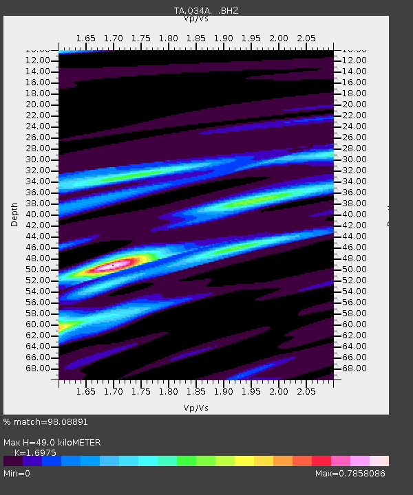
Q34A Chapman, KS, USA - Earthquake Result Viewer

Earthquake location: Off East Coast Of Honshu, Japan
Earthquake latitude/longitude: 40.9/144.9
Earthquake time(UTC): 2012/03/14 (074) 09:08:35 GMT
Earthquake Depth: 12 km
Earthquake Magnitude: 6.7 MB, 6.9 MS, 6.9 MW, 7.0 MW
Earthquake Catalog/Contributor: WHDF/NEIC
Network: TA USArray Transportable Network (new EarthScope stations)
Station: Q34A Chapman, KS, USA
Lat/Lon: 38.92 N/96.94 W
Elevation: 378 m
Distance: 82.6 deg
Az: 43.935 deg
Baz: 317.595 deg
Ray Param: 0.04679087
Estimated Moho Depth: 49.0 km
Estimated Crust Vp/Vs: 1.70
Assumed Crust Vp: 6.483 km/s
Estimated Crust Vs: 3.819 km/s
Estimated Crust Poisson's Ratio: 0.23
Radial Match: 98.08891 %
Radial Bump: 358
Transverse Match: 92.583664 %
Transverse Bump: 400
SOD ConfigId: 440406
Insert Time: 2012-05-25 22:44:45.226 +0000
GWidth: 2.5
Max Bumps: 400
Tol: 0.001

Signal To Noise

ChannelStoNSTALTA
TA:Q34A: :BHZ:20120314T09:20:26.424973Z38.213164.5264874E-61.1845362E-7
TA:Q34A: :BHN:20120314T09:20:26.424973Z10.11571.4056092E-61.3895323E-7
TA:Q34A: :BHE:20120314T09:20:26.424973Z12.317221.0251606E-68.322987E-8
Arrivals
Ps5.4 SECOND
PpPs20 SECOND
PsPs/PpSs25 SECOND