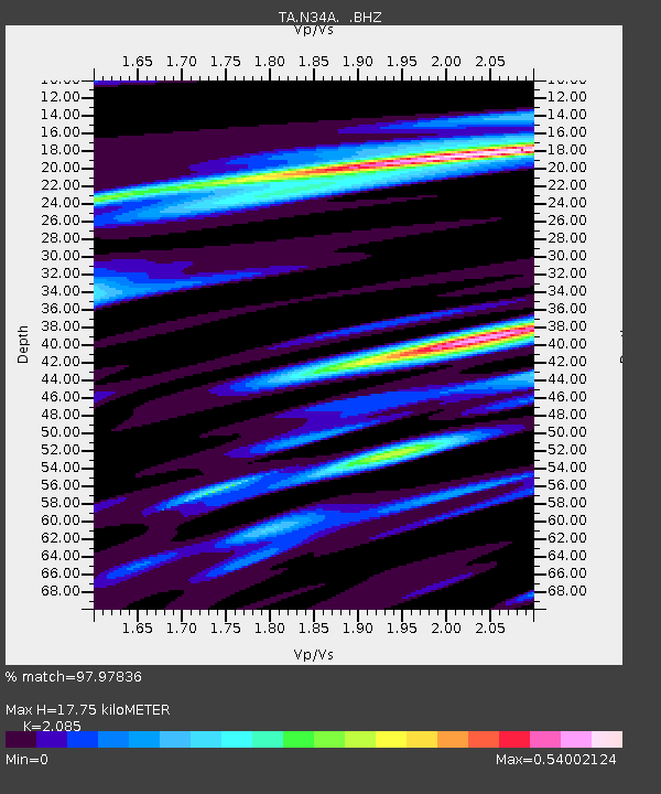
N34A Lincoln, NE, USA - Earthquake Result Viewer
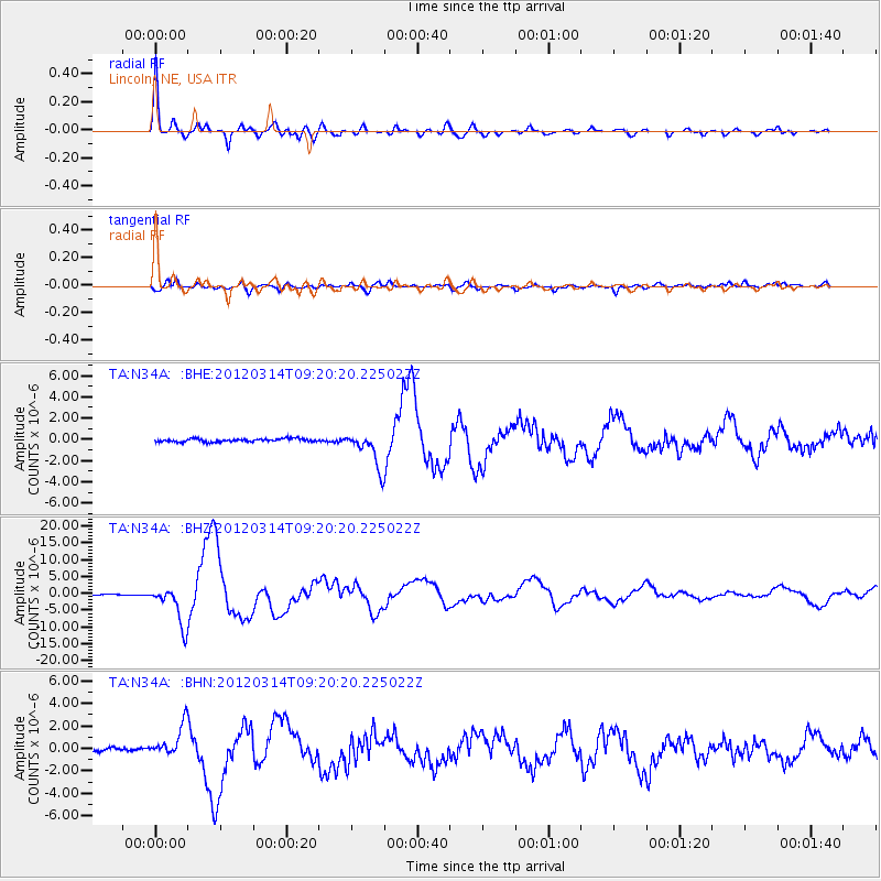
Earthquake location: Off East Coast Of Honshu, Japan
Earthquake latitude/longitude: 40.9/144.9
Earthquake time(UTC): 2012/03/14 (074) 09:08:35 GMT
Earthquake Depth: 12 km
Earthquake Magnitude: 6.7 MB, 6.9 MS, 6.9 MW, 7.0 MW
Earthquake Catalog/Contributor: WHDF/NEIC
Network: TA USArray Transportable Network (new EarthScope stations)
Station: N34A Lincoln, NE, USA
Lat/Lon: 40.84 N/96.50 W
Elevation: 401 m
Distance: 81.4 deg
Az: 42.38 deg
Baz: 317.659 deg
Ray Param: 0.047619462
Estimated Moho Depth: 17.75 km
Estimated Crust Vp/Vs: 2.09
Assumed Crust Vp: 6.498 km/s
Estimated Crust Vs: 3.116 km/s
Estimated Crust Poisson's Ratio: 0.35
Radial Match: 97.97836 %
Radial Bump: 314
Transverse Match: 85.576385 %
Transverse Bump: 400
SOD ConfigId: 440406
Insert Time: 2012-05-25 22:44:49.896 +0000
GWidth: 2.5
Max Bumps: 400
Tol: 0.001

Signal To Noise

ChannelStoNSTALTA
TA:N34A: :BHZ:20120314T09:20:20.225022Z46.9636085.8140204E-61.2379842E-7
TA:N34A: :BHN:20120314T09:20:20.225022Z9.8053131.4024695E-61.4303158E-7
TA:N34A: :BHE:20120314T09:20:20.225022Z11.7649341.6894824E-61.4360323E-7
Arrivals
Ps3.0 SECOND
PpPs8.2 SECOND
PsPs/PpSs11 SECOND