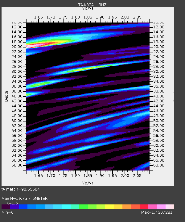
K33A Hardington, NE, USA - Earthquake Result Viewer
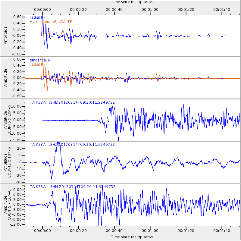
Earthquake location: Off East Coast Of Honshu, Japan
Earthquake latitude/longitude: 40.9/144.9
Earthquake time(UTC): 2012/03/14 (074) 09:08:35 GMT
Earthquake Depth: 12 km
Earthquake Magnitude: 6.7 MB, 6.9 MS, 6.9 MW, 7.0 MW
Earthquake Catalog/Contributor: WHDF/NEIC
Network: TA USArray Transportable Network (new EarthScope stations)
Station: K33A Hardington, NE, USA
Lat/Lon: 42.61 N/97.00 W
Elevation: 507 m
Distance: 79.8 deg
Az: 41.448 deg
Baz: 317.175 deg
Ray Param: 0.048687097
Estimated Moho Depth: 19.75 km
Estimated Crust Vp/Vs: 1.60
Assumed Crust Vp: 6.498 km/s
Estimated Crust Vs: 4.061 km/s
Estimated Crust Poisson's Ratio: 0.18
Radial Match: 90.55504 %
Radial Bump: 400
Transverse Match: 62.85456 %
Transverse Bump: 400
SOD ConfigId: 440406
Insert Time: 2012-05-25 22:46:43.824 +0000
GWidth: 2.5
Max Bumps: 400
Tol: 0.001

Signal To Noise

ChannelStoNSTALTA
TA:K33A: :BHZ:20120314T09:20:11.924973Z41.5632445.3504614E-61.287306E-7
TA:K33A: :BHN:20120314T09:20:11.924973Z7.50815961.2204591E-61.6255103E-7
TA:K33A: :BHE:20120314T09:20:11.924973Z10.4726311.5257268E-61.4568705E-7
Arrivals
Ps1.9 SECOND
PpPs7.7 SECOND
PsPs/PpSs9.5 SECOND