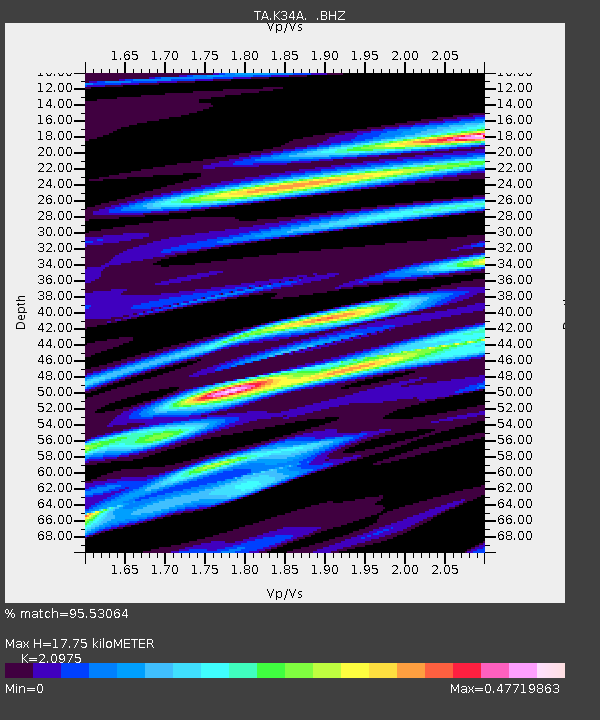
K34A Le Mars, IA, USA - Earthquake Result Viewer

Earthquake location: Off East Coast Of Honshu, Japan
Earthquake latitude/longitude: 40.9/144.9
Earthquake time(UTC): 2012/03/14 (074) 09:08:35 GMT
Earthquake Depth: 12 km
Earthquake Magnitude: 6.7 MB, 6.9 MS, 6.9 MW, 7.0 MW
Earthquake Catalog/Contributor: WHDF/NEIC
Network: TA USArray Transportable Network (new EarthScope stations)
Station: K34A Le Mars, IA, USA
Lat/Lon: 42.69 N/96.10 W
Elevation: 436 m
Distance: 80.2 deg
Az: 40.893 deg
Baz: 317.69 deg
Ray Param: 0.04841897
Estimated Moho Depth: 17.75 km
Estimated Crust Vp/Vs: 2.10
Assumed Crust Vp: 6.498 km/s
Estimated Crust Vs: 3.098 km/s
Estimated Crust Poisson's Ratio: 0.35
Radial Match: 95.53064 %
Radial Bump: 400
Transverse Match: 83.55909 %
Transverse Bump: 400
SOD ConfigId: 440406
Insert Time: 2012-05-25 22:47:19.788 +0000
GWidth: 2.5
Max Bumps: 400
Tol: 0.001

Signal To Noise

ChannelStoNSTALTA
TA:K34A: :BHZ:20120314T09:20:14.02501Z33.6340835.417857E-61.6108237E-7
TA:K34A: :BHN:20120314T09:20:14.02501Z10.1762621.1981588E-61.17740555E-7
TA:K34A: :BHE:20120314T09:20:14.02501Z7.83720161.3981012E-61.7839291E-7
Arrivals
Ps3.1 SECOND
PpPs8.3 SECOND
PsPs/PpSs11 SECOND