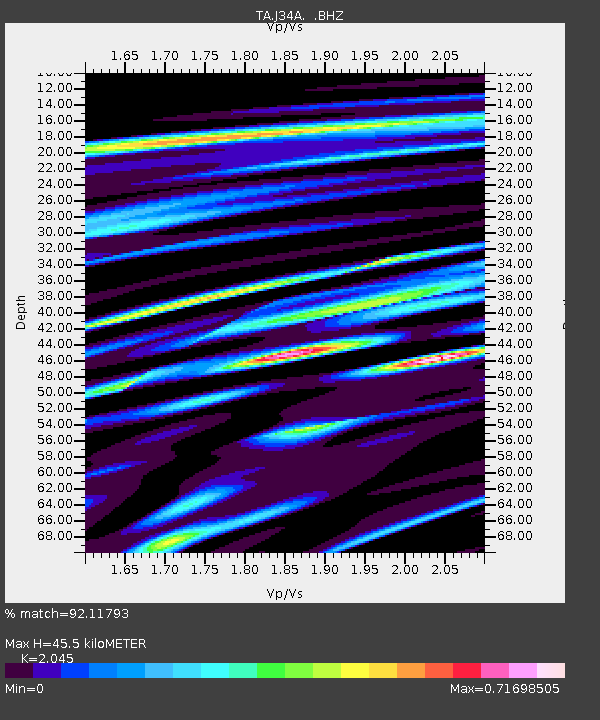
J34A George, IA, USA - Earthquake Result Viewer
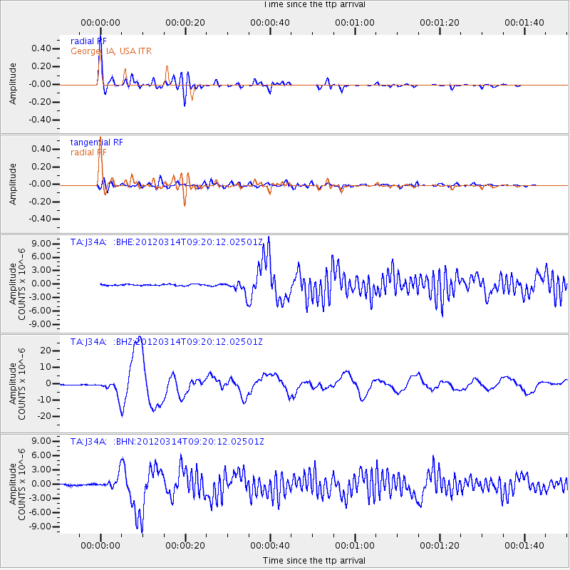
Earthquake location: Off East Coast Of Honshu, Japan
Earthquake latitude/longitude: 40.9/144.9
Earthquake time(UTC): 2012/03/14 (074) 09:08:35 GMT
Earthquake Depth: 12 km
Earthquake Magnitude: 6.7 MB, 6.9 MS, 6.9 MW, 7.0 MW
Earthquake Catalog/Contributor: WHDF/NEIC
Network: TA USArray Transportable Network (new EarthScope stations)
Station: J34A George, IA, USA
Lat/Lon: 43.28 N/95.96 W
Elevation: 432 m
Distance: 79.9 deg
Az: 40.408 deg
Baz: 317.7 deg
Ray Param: 0.048674658
Estimated Moho Depth: 45.5 km
Estimated Crust Vp/Vs: 2.05
Assumed Crust Vp: 6.53 km/s
Estimated Crust Vs: 3.193 km/s
Estimated Crust Poisson's Ratio: 0.34
Radial Match: 92.11793 %
Radial Bump: 400
Transverse Match: 67.9958 %
Transverse Bump: 400
SOD ConfigId: 440406
Insert Time: 2012-05-25 22:47:58.509 +0000
GWidth: 2.5
Max Bumps: 400
Tol: 0.001

Signal To Noise

ChannelStoNSTALTA
TA:J34A: :BHZ:20120314T09:20:12.02501Z34.2343835.0789167E-61.4835719E-7
TA:J34A: :BHN:20120314T09:20:12.02501Z10.3849471.5334692E-61.4766269E-7
TA:J34A: :BHE:20120314T09:20:12.02501Z10.9459461.5080695E-61.3777426E-7
Arrivals
Ps7.5 SECOND
PpPs21 SECOND
PsPs/PpSs28 SECOND