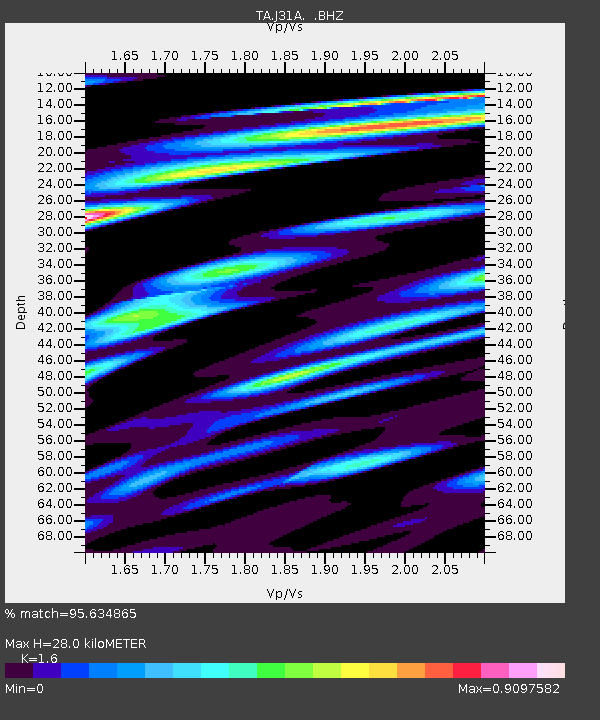
J31A Geddes, SD, USA - Earthquake Result Viewer
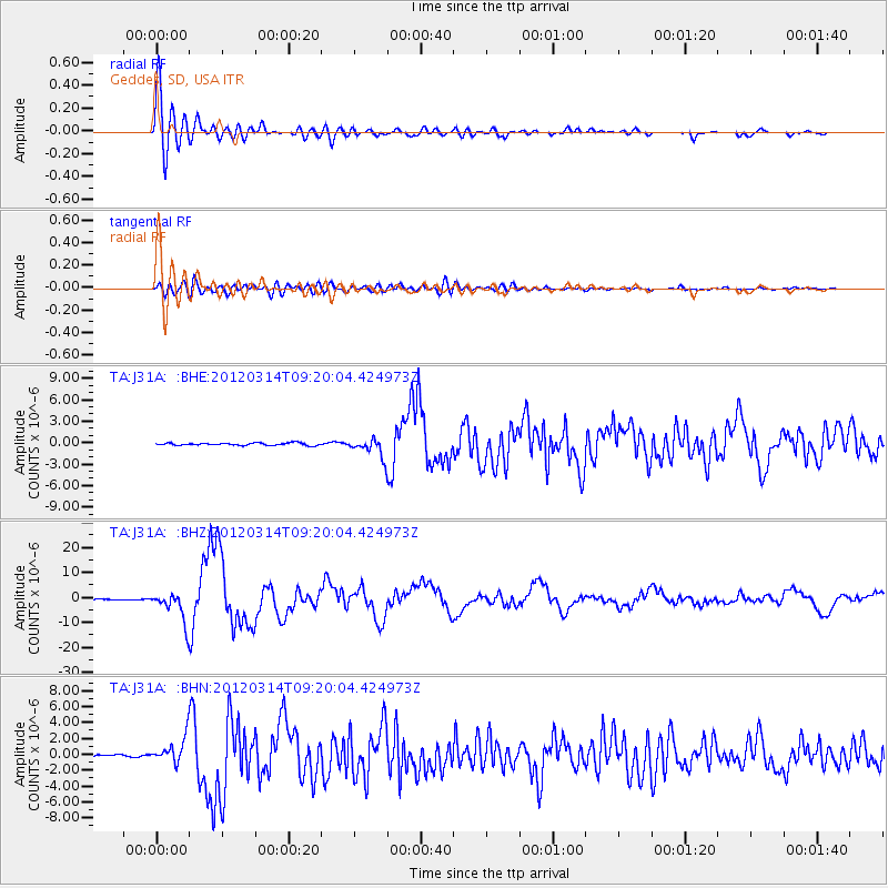
Earthquake location: Off East Coast Of Honshu, Japan
Earthquake latitude/longitude: 40.9/144.9
Earthquake time(UTC): 2012/03/14 (074) 09:08:35 GMT
Earthquake Depth: 12 km
Earthquake Magnitude: 6.7 MB, 6.9 MS, 6.9 MW, 7.0 MW
Earthquake Catalog/Contributor: WHDF/NEIC
Network: TA USArray Transportable Network (new EarthScope stations)
Station: J31A Geddes, SD, USA
Lat/Lon: 43.29 N/98.74 W
Elevation: 491 m
Distance: 78.5 deg
Az: 41.913 deg
Baz: 316.082 deg
Ray Param: 0.04962488
Estimated Moho Depth: 28.0 km
Estimated Crust Vp/Vs: 1.60
Assumed Crust Vp: 6.53 km/s
Estimated Crust Vs: 4.082 km/s
Estimated Crust Poisson's Ratio: 0.18
Radial Match: 95.634865 %
Radial Bump: 400
Transverse Match: 83.15134 %
Transverse Bump: 400
SOD ConfigId: 440406
Insert Time: 2012-05-25 22:48:12.264 +0000
GWidth: 2.5
Max Bumps: 400
Tol: 0.001

Signal To Noise

ChannelStoNSTALTA
TA:J31A: :BHZ:20120314T09:20:04.424973Z58.6165545.9547174E-61.01587645E-7
TA:J31A: :BHN:20120314T09:20:04.424973Z12.0018331.5675239E-61.3060705E-7
TA:J31A: :BHE:20120314T09:20:04.424973Z7.7100921.315842E-61.7066489E-7
Arrivals
Ps2.7 SECOND
PpPs11 SECOND
PsPs/PpSs13 SECOND