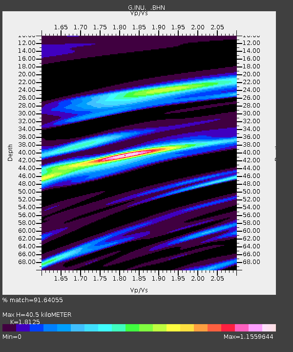
INU Inuyama, Japan - Earthquake Result Viewer

Earthquake location: New Britain Region, P.N.G.
Earthquake latitude/longitude: -5.6/149.6
Earthquake time(UTC): 1999/04/05 (095) 11:08:04 GMT
Earthquake Depth: 150 km
Earthquake Magnitude: 6.2 MB, 7.0 MS, 7.4 MW, 7.3 ME
Earthquake Catalog/Contributor: WHDF/NEIC
Network: G GEOSCOPE
Station: INU Inuyama, Japan
Lat/Lon: 35.35 N/137.03 E
Elevation: 132 m
Distance: 42.4 deg
Az: 344.74 deg
Baz: 161.309 deg
Ray Param: 0.07264861
Estimated Moho Depth: 40.5 km
Estimated Crust Vp/Vs: 1.81
Assumed Crust Vp: 6.461 km/s
Estimated Crust Vs: 3.565 km/s
Estimated Crust Poisson's Ratio: 0.28
Radial Match: 91.64055 %
Radial Bump: 400
Transverse Match: 80.14672 %
Transverse Bump: 400
SOD ConfigId: 4480
Insert Time: 2010-02-26 23:20:11.144 +0000
GWidth: 2.5
Max Bumps: 400
Tol: 0.001

Signal To Noise

ChannelStoNSTALTA
G:INU: :BHN:19990405T11:15:13.174988Z5.512732.9938742E-65.4308373E-7
G:INU: :BHE:19990405T11:15:13.174988Z3.08778741.3639848E-64.4173532E-7
G:INU: :BHZ:19990405T11:15:13.174988Z3.3759327.467306E-72.2119244E-7
Arrivals
Ps5.4 SECOND
PpPs17 SECOND
PsPs/PpSs22 SECOND