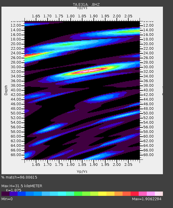
E31A Nome, ND, USA - Earthquake Result Viewer
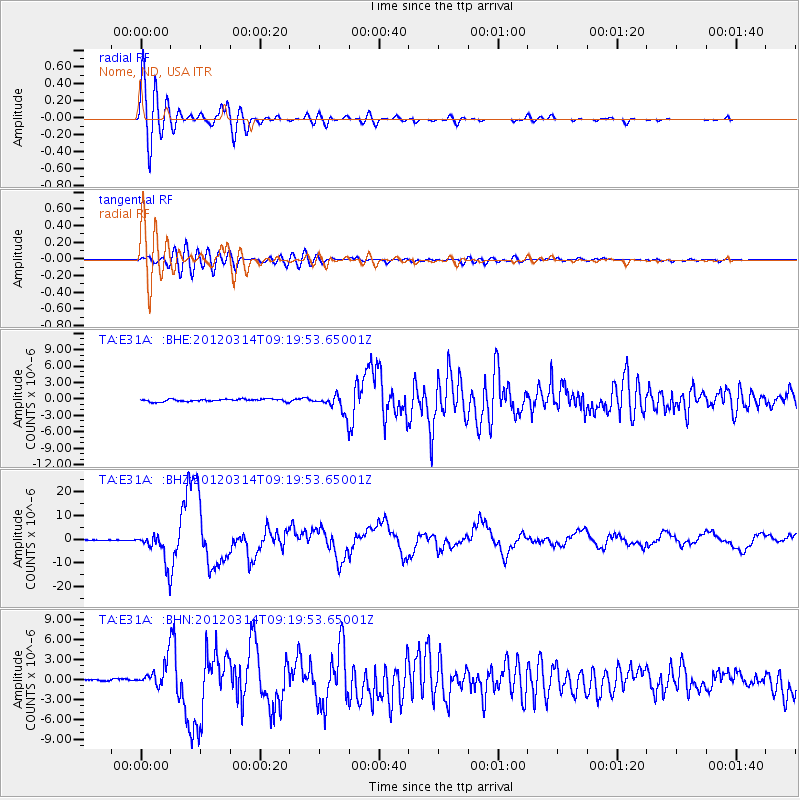
Earthquake location: Off East Coast Of Honshu, Japan
Earthquake latitude/longitude: 40.9/144.9
Earthquake time(UTC): 2012/03/14 (074) 09:08:35 GMT
Earthquake Depth: 12 km
Earthquake Magnitude: 6.7 MB, 6.9 MS, 6.9 MW, 7.0 MW
Earthquake Catalog/Contributor: WHDF/NEIC
Network: TA USArray Transportable Network (new EarthScope stations)
Station: E31A Nome, ND, USA
Lat/Lon: 46.56 N/97.89 W
Elevation: 427 m
Distance: 76.5 deg
Az: 39.146 deg
Baz: 316.082 deg
Ray Param: 0.050933212
Estimated Moho Depth: 31.5 km
Estimated Crust Vp/Vs: 1.88
Assumed Crust Vp: 6.498 km/s
Estimated Crust Vs: 3.465 km/s
Estimated Crust Poisson's Ratio: 0.30
Radial Match: 96.88615 %
Radial Bump: 400
Transverse Match: 84.549866 %
Transverse Bump: 400
SOD ConfigId: 440406
Insert Time: 2012-05-25 22:49:05.783 +0000
GWidth: 2.5
Max Bumps: 400
Tol: 0.001

Signal To Noise

ChannelStoNSTALTA
TA:E31A: :BHZ:20120314T09:19:53.65001Z74.563196.530294E-68.758067E-8
TA:E31A: :BHN:20120314T09:19:53.65001Z9.1697721.9175736E-62.0911902E-7
TA:E31A: :BHE:20120314T09:19:53.65001Z7.6045521.725029E-62.2684165E-7
Arrivals
Ps4.4 SECOND
PpPs14 SECOND
PsPs/PpSs18 SECOND