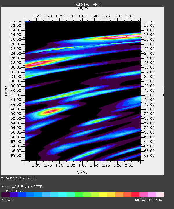
K31A O'Neill, NE, USA - Earthquake Result Viewer

Earthquake location: Off East Coast Of Honshu, Japan
Earthquake latitude/longitude: 40.9/144.9
Earthquake time(UTC): 2012/03/14 (074) 09:08:35 GMT
Earthquake Depth: 12 km
Earthquake Magnitude: 6.7 MB, 6.9 MS, 6.9 MW, 7.0 MW
Earthquake Catalog/Contributor: WHDF/NEIC
Network: TA USArray Transportable Network (new EarthScope stations)
Station: K31A O'Neill, NE, USA
Lat/Lon: 42.62 N/98.75 W
Elevation: 580 m
Distance: 78.9 deg
Az: 42.394 deg
Baz: 316.166 deg
Ray Param: 0.04930374
Estimated Moho Depth: 16.5 km
Estimated Crust Vp/Vs: 2.04
Assumed Crust Vp: 6.53 km/s
Estimated Crust Vs: 3.205 km/s
Estimated Crust Poisson's Ratio: 0.34
Radial Match: 92.84881 %
Radial Bump: 400
Transverse Match: 83.667336 %
Transverse Bump: 400
SOD ConfigId: 440406
Insert Time: 2012-05-25 22:49:19.216 +0000
GWidth: 2.5
Max Bumps: 400
Tol: 0.001

Signal To Noise

ChannelStoNSTALTA
TA:K31A: :BHZ:20120314T09:20:07.02501Z35.9140624.8514817E-61.3508584E-7
TA:K31A: :BHN:20120314T09:20:07.02501Z12.3418871.9044033E-61.5430406E-7
TA:K31A: :BHE:20120314T09:20:07.02501Z7.9728581.0023151E-61.257159E-7
Arrivals
Ps2.7 SECOND
PpPs7.5 SECOND
PsPs/PpSs10 SECOND