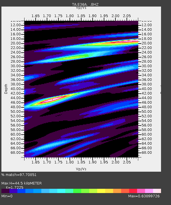
E36A McGregor, MN, USA - Earthquake Result Viewer
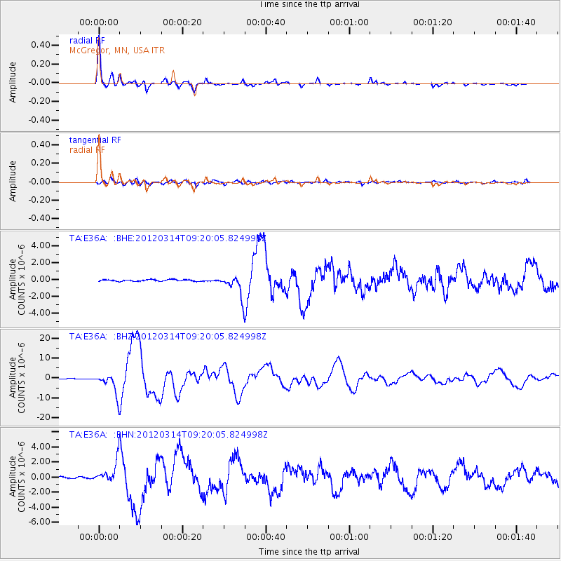
Earthquake location: Off East Coast Of Honshu, Japan
Earthquake latitude/longitude: 40.9/144.9
Earthquake time(UTC): 2012/03/14 (074) 09:08:35 GMT
Earthquake Depth: 12 km
Earthquake Magnitude: 6.7 MB, 6.9 MS, 6.9 MW, 7.0 MW
Earthquake Catalog/Contributor: WHDF/NEIC
Network: TA USArray Transportable Network (new EarthScope stations)
Station: E36A McGregor, MN, USA
Lat/Lon: 46.52 N/93.26 W
Elevation: 393 m
Distance: 78.7 deg
Az: 36.761 deg
Baz: 318.923 deg
Ray Param: 0.049450852
Estimated Moho Depth: 44.5 km
Estimated Crust Vp/Vs: 1.72
Assumed Crust Vp: 6.571 km/s
Estimated Crust Vs: 3.815 km/s
Estimated Crust Poisson's Ratio: 0.25
Radial Match: 97.70851 %
Radial Bump: 298
Transverse Match: 85.18019 %
Transverse Bump: 400
SOD ConfigId: 440406
Insert Time: 2012-05-25 22:54:43.876 +0000
GWidth: 2.5
Max Bumps: 400
Tol: 0.001

Signal To Noise

ChannelStoNSTALTA
TA:E36A: :BHZ:20120314T09:20:05.824998Z46.6582575.467161E-61.17174565E-7
TA:E36A: :BHN:20120314T09:20:05.824998Z11.7043111.4514574E-61.240105E-7
TA:E36A: :BHE:20120314T09:20:05.824998Z14.5777921.3862629E-69.509415E-8
Arrivals
Ps5.1 SECOND
PpPs18 SECOND
PsPs/PpSs23 SECOND