You are here: Home > Network List > TA - USArray Transportable Network (new EarthScope stations) Stations List
> Station L37A Phoenix Point, Boone, IA, USA > Earthquake Result Viewer
L37A Phoenix Point, Boone, IA, USA - Earthquake Result Viewer
| Earthquake location: |
Off East Coast Of Honshu, Japan |
| Earthquake latitude/longitude: |
40.9/144.9 |
| Earthquake time(UTC): |
2012/03/14 (074) 09:08:35 GMT |
| Earthquake Depth: |
12 km |
| Earthquake Magnitude: |
6.7 MB, 6.9 MS, 6.9 MW, 7.0 MW |
| Earthquake Catalog/Contributor: |
WHDF/NEIC |
|
| Network: |
TA USArray Transportable Network (new EarthScope stations) |
| Station: |
L37A Phoenix Point, Boone, IA, USA |
| Lat/Lon: |
42.12 N/93.75 W |
| Elevation: |
312 m |
|
| Distance: |
81.8 deg |
| Az: |
39.957 deg |
| Baz: |
319.117 deg |
| Ray Param: |
0.047331974 |
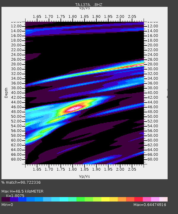
| Estimated Moho Depth: |
46.5 km |
| Estimated Crust Vp/Vs: |
1.81 |
| Assumed Crust Vp: |
6.53 km/s |
| Estimated Crust Vs: |
3.613 km/s |
| Estimated Crust Poisson's Ratio: |
0.28 |
|
| Radial Match: |
98.722336 % |
| Radial Bump: |
252 |
| Transverse Match: |
96.3256 % |
| Transverse Bump: |
400 |
| SOD ConfigId: |
440406 |
| Insert Time: |
2012-05-25 22:56:03.320 +0000 |
| GWidth: |
2.5 |
| Max Bumps: |
400 |
| Tol: |
0.001 |
|
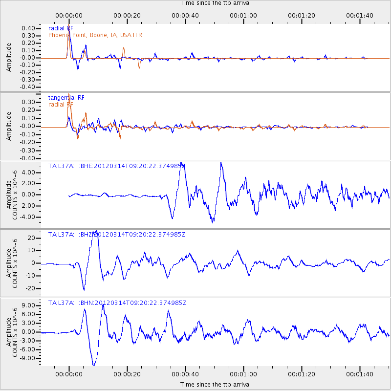
Signal To Noise
| Channel | StoN | STA | LTA |
| TA:L37A: :BHZ:20120314T09:20:22.374985Z | 28.743174 | 5.012215E-6 | 1.7437931E-7 |
| TA:L37A: :BHN:20120314T09:20:22.374985Z | 8.262952 | 1.4185215E-6 | 1.7167248E-7 |
| TA:L37A: :BHE:20120314T09:20:22.374985Z | 4.3816667 | 7.343644E-7 | 1.6759934E-7 |
| Arrivals |
| Ps | 5.9 SECOND |
| PpPs | 19 SECOND |
| PsPs/PpSs | 25 SECOND |


