You are here: Home > Network List > TA - USArray Transportable Network (new EarthScope stations) Stations List
> Station N36A Muff Farm, Clarinda, IA, USA > Earthquake Result Viewer
N36A Muff Farm, Clarinda, IA, USA - Earthquake Result Viewer
| Earthquake location: |
Off East Coast Of Honshu, Japan |
| Earthquake latitude/longitude: |
40.9/144.9 |
| Earthquake time(UTC): |
2012/03/14 (074) 09:08:35 GMT |
| Earthquake Depth: |
12 km |
| Earthquake Magnitude: |
6.7 MB, 6.9 MS, 6.9 MW, 7.0 MW |
| Earthquake Catalog/Contributor: |
WHDF/NEIC |
|
| Network: |
TA USArray Transportable Network (new EarthScope stations) |
| Station: |
N36A Muff Farm, Clarinda, IA, USA |
| Lat/Lon: |
40.82 N/94.96 W |
| Elevation: |
349 m |
|
| Distance: |
82.2 deg |
| Az: |
41.516 deg |
| Baz: |
318.539 deg |
| Ray Param: |
0.047060378 |
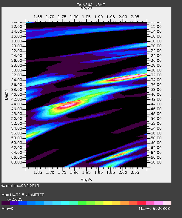
| Estimated Moho Depth: |
32.5 km |
| Estimated Crust Vp/Vs: |
2.03 |
| Assumed Crust Vp: |
6.498 km/s |
| Estimated Crust Vs: |
3.209 km/s |
| Estimated Crust Poisson's Ratio: |
0.34 |
|
| Radial Match: |
98.12819 % |
| Radial Bump: |
400 |
| Transverse Match: |
93.46465 % |
| Transverse Bump: |
400 |
| SOD ConfigId: |
440406 |
| Insert Time: |
2012-05-25 22:56:37.946 +0000 |
| GWidth: |
2.5 |
| Max Bumps: |
400 |
| Tol: |
0.001 |
|

Signal To Noise
| Channel | StoN | STA | LTA |
| TA:N36A: :BHZ:20120314T09:20:24.40001Z | 40.0452 | 4.020092E-6 | 1.0038886E-7 |
| TA:N36A: :BHN:20120314T09:20:24.40001Z | 5.8530674 | 8.8410826E-7 | 1.5105041E-7 |
| TA:N36A: :BHE:20120314T09:20:24.40001Z | 7.069666 | 9.711912E-7 | 1.3737441E-7 |
| Arrivals |
| Ps | 5.3 SECOND |
| PpPs | 15 SECOND |
| PsPs/PpSs | 20 SECOND |


