P38A Dawn, MO, USA - Earthquake Result Viewer
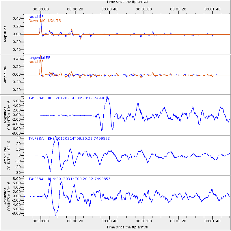
Earthquake location: Off East Coast Of Honshu, Japan
Earthquake latitude/longitude: 40.9/144.9
Earthquake time(UTC): 2012/03/14 (074) 09:08:35 GMT
Earthquake Depth: 12 km
Earthquake Magnitude: 6.7 MB, 6.9 MS, 6.9 MW, 7.0 MW
Earthquake Catalog/Contributor: WHDF/NEIC
Network: TA USArray Transportable Network (new EarthScope stations)
Station: P38A Dawn, MO, USA
Lat/Lon: 39.62 N/93.53 W
Elevation: 248 m
Distance: 83.8 deg
Az: 41.47 deg
Baz: 319.452 deg
Ray Param: 0.045928005
Estimated Moho Depth: 43.25 km
Estimated Crust Vp/Vs: 1.76
Assumed Crust Vp: 6.498 km/s
Estimated Crust Vs: 3.687 km/s
Estimated Crust Poisson's Ratio: 0.26
Radial Match: 98.62197 %
Radial Bump: 249
Transverse Match: 93.015305 %
Transverse Bump: 400
SOD ConfigId: 440406
Insert Time: 2012-05-25 22:56:48.461 +0000
GWidth: 2.5
Max Bumps: 400
Tol: 0.001

Signal To Noise

ChannelStoNSTALTA
TA:P38A: :BHZ:20120314T09:20:32.749985Z26.4961993.890005E-61.4681369E-7
TA:P38A: :BHN:20120314T09:20:32.749985Z6.80070541.0881186E-61.6000084E-7
TA:P38A: :BHE:20120314T09:20:32.749985Z7.69299559.767808E-71.2697016E-7
Arrivals
Ps5.2 SECOND
PpPs18 SECOND
PsPs/PpSs23 SECOND