You are here: Home > Network List > TA - USArray Transportable Network (new EarthScope stations) Stations List
> Station T40A Mansfield, MO, USA > Earthquake Result Viewer
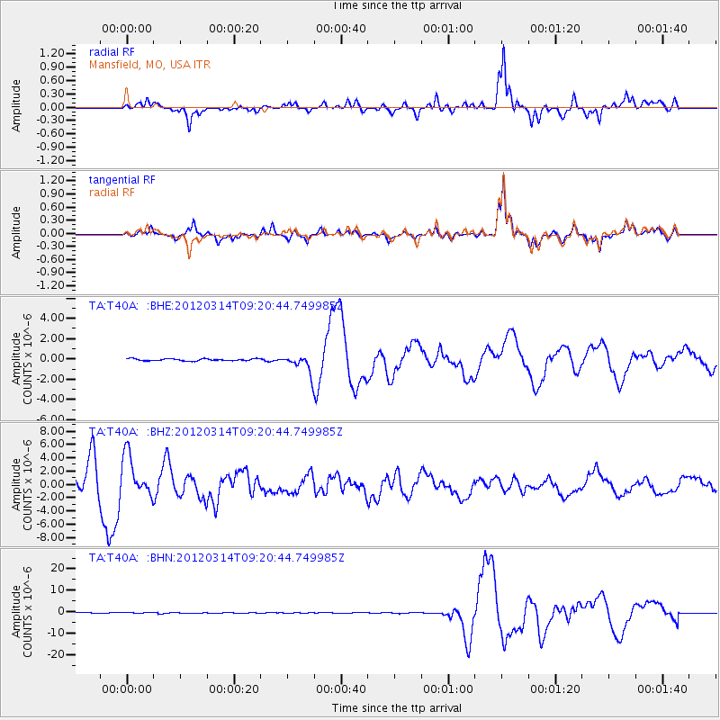
T40A Mansfield, MO, USA - Earthquake Result Viewer
*The percent match for this event was below the threshold and hence no stack was calculated.
| Earthquake location: |
Off East Coast Of Honshu, Japan |
| Earthquake latitude/longitude: |
40.9/144.9 |
| Earthquake time(UTC): |
2012/03/14 (074) 09:08:35 GMT |
| Earthquake Depth: |
12 km |
| Earthquake Magnitude: |
6.7 MB, 6.9 MS, 6.9 MW, 7.0 MW |
| Earthquake Catalog/Contributor: |
WHDF/NEIC |
|
| Network: |
TA USArray Transportable Network (new EarthScope stations) |
| Station: |
T40A Mansfield, MO, USA |
| Lat/Lon: |
37.15 N/92.52 W |
| Elevation: |
399 m |
|
| Distance: |
86.2 deg |
| Az: |
42.46 deg |
| Baz: |
320.165 deg |
| Ray Param: |
$rayparam |
*The percent match for this event was below the threshold and hence was not used in the summary stack. |
|
| Radial Match: |
81.004776 % |
| Radial Bump: |
334 |
| Transverse Match: |
81.54186 % |
| Transverse Bump: |
342 |
| SOD ConfigId: |
440406 |
| Insert Time: |
2012-05-25 22:57:52.775 +0000 |
| GWidth: |
2.5 |
| Max Bumps: |
400 |
| Tol: |
0.001 |
|
Signal To Noise
| Channel | StoN | STA | LTA |
| TA:T40A: :BHZ:20120314T09:20:44.749985Z | 2.044424 | 3.068929E-6 | 1.5011216E-6 |
| TA:T40A: :BHN:20120314T09:20:44.749985Z | 1.0540384 | 1.4498461E-7 | 1.3755155E-7 |
| TA:T40A: :BHE:20120314T09:20:44.749985Z | 9.212018 | 9.097373E-7 | 9.875548E-8 |
| Arrivals |
| Ps | |
| PpPs | |
| PsPs/PpSs | |


