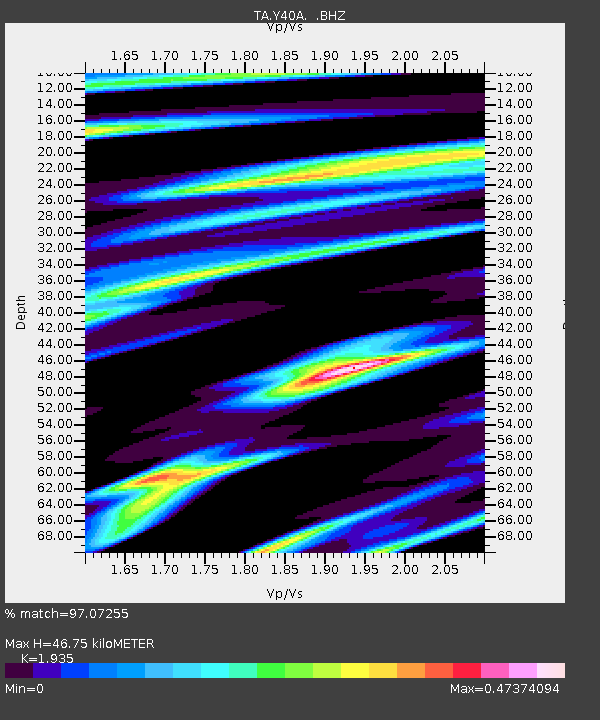
Y40A Okolona, AR, USA - Earthquake Result Viewer
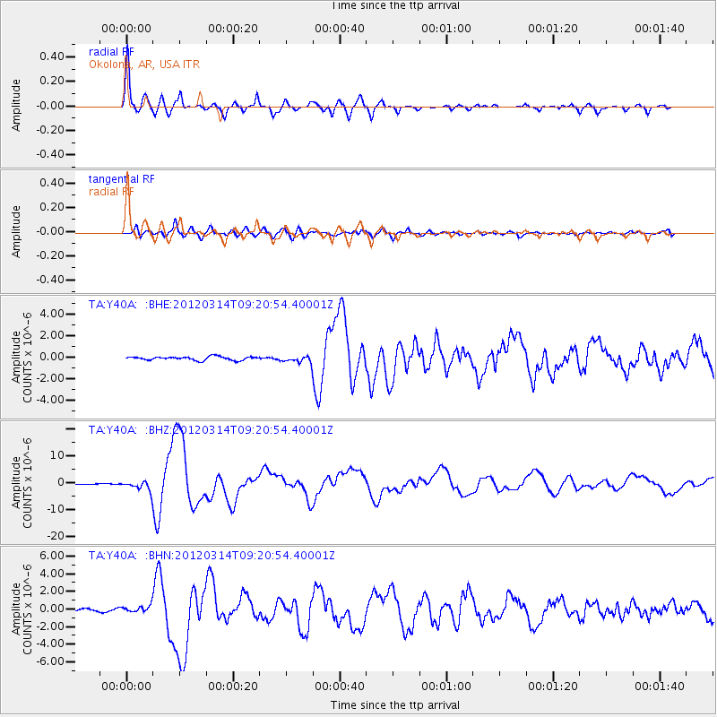
Earthquake location: Off East Coast Of Honshu, Japan
Earthquake latitude/longitude: 40.9/144.9
Earthquake time(UTC): 2012/03/14 (074) 09:08:35 GMT
Earthquake Depth: 12 km
Earthquake Magnitude: 6.7 MB, 6.9 MS, 6.9 MW, 7.0 MW
Earthquake Catalog/Contributor: WHDF/NEIC
Network: TA USArray Transportable Network (new EarthScope stations)
Station: Y40A Okolona, AR, USA
Lat/Lon: 34.01 N/93.28 W
Elevation: 117 m
Distance: 88.2 deg
Az: 44.951 deg
Baz: 319.846 deg
Ray Param: 0.042760283
Estimated Moho Depth: 46.75 km
Estimated Crust Vp/Vs: 1.93
Assumed Crust Vp: 6.498 km/s
Estimated Crust Vs: 3.358 km/s
Estimated Crust Poisson's Ratio: 0.32
Radial Match: 97.07255 %
Radial Bump: 400
Transverse Match: 89.48042 %
Transverse Bump: 400
SOD ConfigId: 440406
Insert Time: 2012-05-25 22:58:30.099 +0000
GWidth: 2.5
Max Bumps: 400
Tol: 0.001

Signal To Noise

ChannelStoNSTALTA
TA:Y40A: :BHZ:20120314T09:20:54.40001Z9.4910571.8471455E-61.9461956E-7
TA:Y40A: :BHN:20120314T09:20:54.40001Z3.0897673.781882E-71.2240024E-7
TA:Y40A: :BHE:20120314T09:20:54.40001Z1.89746463.2069082E-71.6901016E-7
Arrivals
Ps6.9 SECOND
PpPs21 SECOND
PsPs/PpSs28 SECOND