You are here: Home > Network List > TA - USArray Transportable Network (new EarthScope stations) Stations List
> Station 144A alexander Place, Bentonia, MS, USA > Earthquake Result Viewer
144A alexander Place, Bentonia, MS, USA - Earthquake Result Viewer
| Earthquake location: |
Off East Coast Of Honshu, Japan |
| Earthquake latitude/longitude: |
40.9/144.9 |
| Earthquake time(UTC): |
2012/03/14 (074) 09:08:35 GMT |
| Earthquake Depth: |
12 km |
| Earthquake Magnitude: |
6.7 MB, 6.9 MS, 6.9 MW, 7.0 MW |
| Earthquake Catalog/Contributor: |
WHDF/NEIC |
|
| Network: |
TA USArray Transportable Network (new EarthScope stations) |
| Station: |
144A alexander Place, Bentonia, MS, USA |
| Lat/Lon: |
32.63 N/90.42 W |
| Elevation: |
78 m |
|
| Distance: |
90.8 deg |
| Az: |
43.976 deg |
| Baz: |
321.399 deg |
| Ray Param: |
0.04164847 |
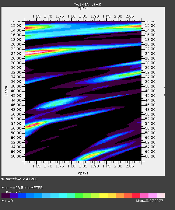
| Estimated Moho Depth: |
23.5 km |
| Estimated Crust Vp/Vs: |
1.62 |
| Assumed Crust Vp: |
6.201 km/s |
| Estimated Crust Vs: |
3.84 km/s |
| Estimated Crust Poisson's Ratio: |
0.19 |
|
| Radial Match: |
92.41208 % |
| Radial Bump: |
400 |
| Transverse Match: |
87.584274 % |
| Transverse Bump: |
400 |
| SOD ConfigId: |
440406 |
| Insert Time: |
2012-05-25 23:01:10.248 +0000 |
| GWidth: |
2.5 |
| Max Bumps: |
400 |
| Tol: |
0.001 |
|

Signal To Noise
| Channel | StoN | STA | LTA |
| TA:144A: :BHZ:20120314T09:21:06.449998Z | 6.3407106 | 1.1098815E-6 | 1.7504055E-7 |
| TA:144A: :BHN:20120314T09:21:06.449998Z | 0.7622946 | 3.867569E-7 | 5.073589E-7 |
| TA:144A: :BHE:20120314T09:21:06.449998Z | 1.2061505 | 4.1650213E-7 | 3.4531521E-7 |
| Arrivals |
| Ps | 2.4 SECOND |
| PpPs | 9.7 SECOND |
| PsPs/PpSs | 12 SECOND |


