You are here: Home > Network List > TA - USArray Transportable Network (new EarthScope stations) Stations List
> Station Z42A Norrel Spur, Hamburg, AR, USA > Earthquake Result Viewer
Z42A Norrel Spur, Hamburg, AR, USA - Earthquake Result Viewer
| Earthquake location: |
Off East Coast Of Honshu, Japan |
| Earthquake latitude/longitude: |
40.9/144.9 |
| Earthquake time(UTC): |
2012/03/14 (074) 09:08:35 GMT |
| Earthquake Depth: |
12 km |
| Earthquake Magnitude: |
6.7 MB, 6.9 MS, 6.9 MW, 7.0 MW |
| Earthquake Catalog/Contributor: |
WHDF/NEIC |
|
| Network: |
TA USArray Transportable Network (new EarthScope stations) |
| Station: |
Z42A Norrel Spur, Hamburg, AR, USA |
| Lat/Lon: |
33.27 N/91.95 W |
| Elevation: |
39 m |
|
| Distance: |
89.5 deg |
| Az: |
44.568 deg |
| Baz: |
320.573 deg |
| Ray Param: |
0.04181833 |
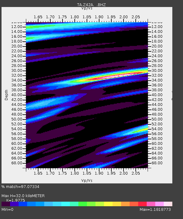
| Estimated Moho Depth: |
32.0 km |
| Estimated Crust Vp/Vs: |
1.98 |
| Assumed Crust Vp: |
6.201 km/s |
| Estimated Crust Vs: |
3.136 km/s |
| Estimated Crust Poisson's Ratio: |
0.33 |
|
| Radial Match: |
97.07334 % |
| Radial Bump: |
400 |
| Transverse Match: |
78.41762 % |
| Transverse Bump: |
400 |
| SOD ConfigId: |
440406 |
| Insert Time: |
2012-05-25 23:03:43.334 +0000 |
| GWidth: |
2.5 |
| Max Bumps: |
400 |
| Tol: |
0.001 |
|
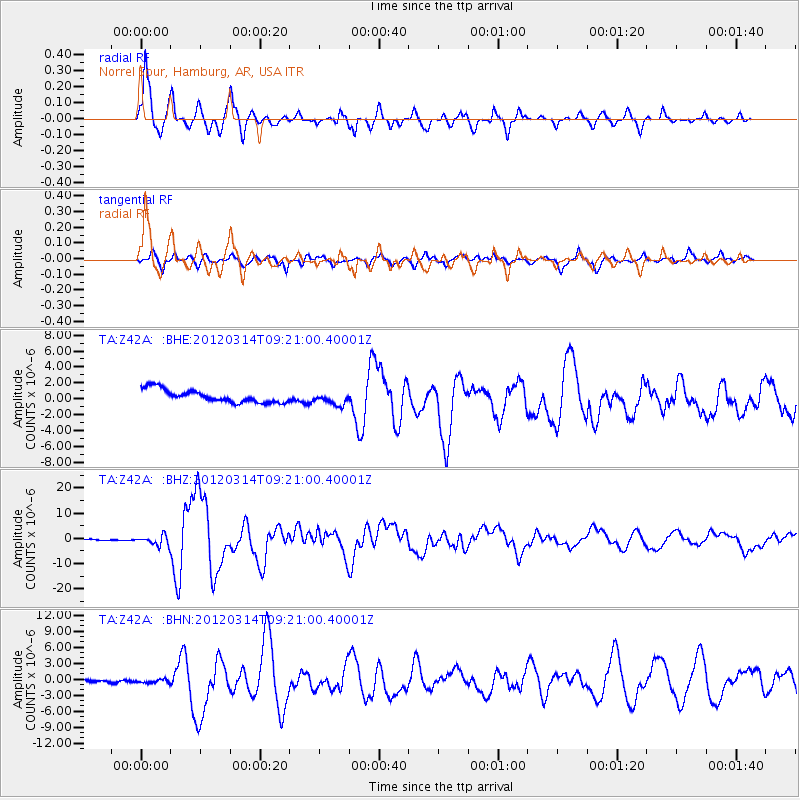
Signal To Noise
| Channel | StoN | STA | LTA |
| TA:Z42A: :BHZ:20120314T09:21:00.40001Z | 9.193281 | 1.9648035E-6 | 2.1372169E-7 |
| TA:Z42A: :BHN:20120314T09:21:00.40001Z | 1.5175958 | 5.206844E-7 | 3.4309824E-7 |
| TA:Z42A: :BHE:20120314T09:21:00.40001Z | 0.96707624 | 7.8018013E-7 | 8.0674107E-7 |
| Arrivals |
| Ps | 5.1 SECOND |
| PpPs | 15 SECOND |
| PsPs/PpSs | 20 SECOND |


