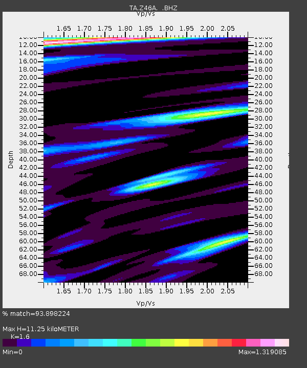
Z46A Louisville, MS, USA - Earthquake Result Viewer
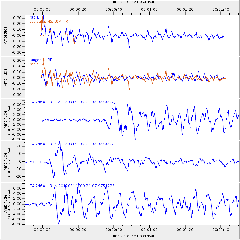
Earthquake location: Off East Coast Of Honshu, Japan
Earthquake latitude/longitude: 40.9/144.9
Earthquake time(UTC): 2012/03/14 (074) 09:08:35 GMT
Earthquake Depth: 12 km
Earthquake Magnitude: 6.7 MB, 6.9 MS, 6.9 MW, 7.0 MW
Earthquake Catalog/Contributor: WHDF/NEIC
Network: TA USArray Transportable Network (new EarthScope stations)
Station: Z46A Louisville, MS, USA
Lat/Lon: 33.19 N/88.94 W
Elevation: 125 m
Distance: 91.1 deg
Az: 42.649 deg
Baz: 322.222 deg
Ray Param: 0.041624993
Estimated Moho Depth: 11.25 km
Estimated Crust Vp/Vs: 1.60
Assumed Crust Vp: 6.201 km/s
Estimated Crust Vs: 3.876 km/s
Estimated Crust Poisson's Ratio: 0.18
Radial Match: 93.898224 %
Radial Bump: 400
Transverse Match: 95.5471 %
Transverse Bump: 400
SOD ConfigId: 440406
Insert Time: 2012-05-25 23:03:56.222 +0000
GWidth: 2.5
Max Bumps: 400
Tol: 0.001

Signal To Noise

ChannelStoNSTALTA
TA:Z46A: :BHZ:20120314T09:21:07.975022Z7.1121511.5227132E-62.1410023E-7
TA:Z46A: :BHN:20120314T09:21:07.975022Z1.62630874.4341616E-72.726519E-7
TA:Z46A: :BHE:20120314T09:21:07.975022Z1.58105953.5552333E-72.2486398E-7
Arrivals
Ps1.1 SECOND
PpPs4.6 SECOND
PsPs/PpSs5.7 SECOND