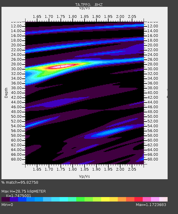
TPFO Pinon Flats, CA, USA - Earthquake Result Viewer
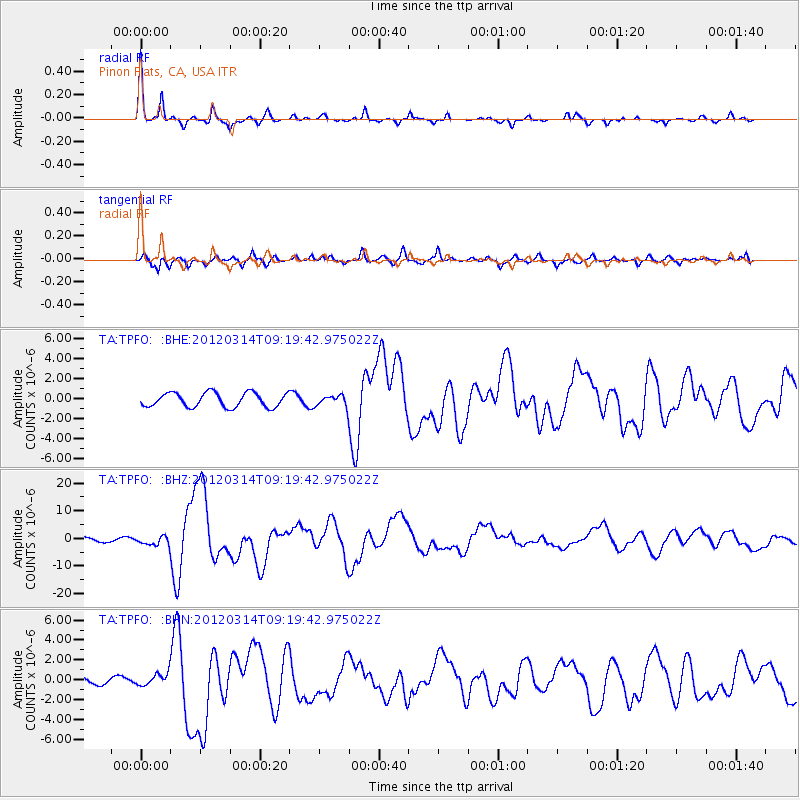
Earthquake location: Off East Coast Of Honshu, Japan
Earthquake latitude/longitude: 40.9/144.9
Earthquake time(UTC): 2012/03/14 (074) 09:08:35 GMT
Earthquake Depth: 12 km
Earthquake Magnitude: 6.7 MB, 6.9 MS, 6.9 MW, 7.0 MW
Earthquake Catalog/Contributor: WHDF/NEIC
Network: TA USArray Transportable Network (new EarthScope stations)
Station: TPFO Pinon Flats, CA, USA
Lat/Lon: 33.61 N/116.45 W
Elevation: 1275 m
Distance: 74.7 deg
Az: 58.835 deg
Baz: 308.982 deg
Ray Param: 0.052181788
Estimated Moho Depth: 28.75 km
Estimated Crust Vp/Vs: 1.75
Assumed Crust Vp: 6.264 km/s
Estimated Crust Vs: 3.584 km/s
Estimated Crust Poisson's Ratio: 0.26
Radial Match: 95.82758 %
Radial Bump: 257
Transverse Match: 77.09701 %
Transverse Bump: 400
SOD ConfigId: 440406
Insert Time: 2012-05-25 23:04:07.762 +0000
GWidth: 2.5
Max Bumps: 400
Tol: 0.001

Signal To Noise

ChannelStoNSTALTA
TA:TPFO: :BHZ:20120314T09:19:42.975022Z2.04632691.6117482E-67.876299E-7
TA:TPFO: :BHN:20120314T09:19:42.975022Z1.35087796.133635E-74.5404812E-7
TA:TPFO: :BHE:20120314T09:19:42.975022Z0.78895275.6233705E-77.1276395E-7
Arrivals
Ps3.5 SECOND
PpPs12 SECOND
PsPs/PpSs16 SECOND