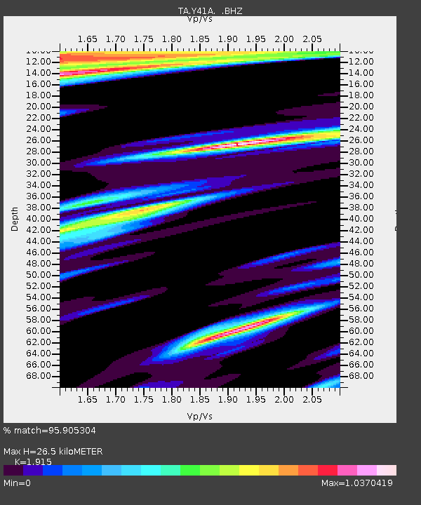
Y41A Eaglette Bearden, AR, USA - Earthquake Result Viewer

Earthquake location: Off East Coast Of Honshu, Japan
Earthquake latitude/longitude: 40.9/144.9
Earthquake time(UTC): 2012/03/14 (074) 09:08:35 GMT
Earthquake Depth: 12 km
Earthquake Magnitude: 6.7 MB, 6.9 MS, 6.9 MW, 7.0 MW
Earthquake Catalog/Contributor: WHDF/NEIC
Network: TA USArray Transportable Network (new EarthScope stations)
Station: Y41A Eaglette Bearden, AR, USA
Lat/Lon: 33.88 N/92.61 W
Elevation: 99 m
Distance: 88.7 deg
Az: 44.609 deg
Baz: 320.208 deg
Ray Param: 0.04241968
Estimated Moho Depth: 26.5 km
Estimated Crust Vp/Vs: 1.91
Assumed Crust Vp: 6.245 km/s
Estimated Crust Vs: 3.261 km/s
Estimated Crust Poisson's Ratio: 0.31
Radial Match: 95.905304 %
Radial Bump: 400
Transverse Match: 93.07107 %
Transverse Bump: 400
SOD ConfigId: 440406
Insert Time: 2012-05-25 23:04:09.962 +0000
GWidth: 2.5
Max Bumps: 400
Tol: 0.001

Signal To Noise

ChannelStoNSTALTA
TA:Y41A: :BHZ:20120314T09:20:56.549973Z12.9804241.6325623E-61.2577111E-7
TA:Y41A: :BHN:20120314T09:20:56.549973Z2.23153923.8834926E-71.7402753E-7
TA:Y41A: :BHE:20120314T09:20:56.549973Z1.96415675.464229E-72.781972E-7
Arrivals
Ps4.0 SECOND
PpPs12 SECOND
PsPs/PpSs16 SECOND