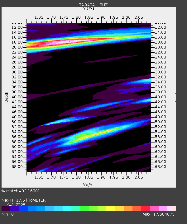
X43A Marvell, AR, USA - Earthquake Result Viewer

Earthquake location: Off East Coast Of Honshu, Japan
Earthquake latitude/longitude: 40.9/144.9
Earthquake time(UTC): 2012/03/14 (074) 09:08:35 GMT
Earthquake Depth: 12 km
Earthquake Magnitude: 6.7 MB, 6.9 MS, 6.9 MW, 7.0 MW
Earthquake Catalog/Contributor: WHDF/NEIC
Network: TA USArray Transportable Network (new EarthScope stations)
Station: X43A Marvell, AR, USA
Lat/Lon: 34.52 N/90.88 W
Elevation: 53 m
Distance: 89.1 deg
Az: 43.097 deg
Baz: 321.146 deg
Ray Param: 0.04211185
Estimated Moho Depth: 17.5 km
Estimated Crust Vp/Vs: 1.77
Assumed Crust Vp: 6.273 km/s
Estimated Crust Vs: 3.539 km/s
Estimated Crust Poisson's Ratio: 0.27
Radial Match: 92.16901 %
Radial Bump: 386
Transverse Match: 82.88287 %
Transverse Bump: 400
SOD ConfigId: 440406
Insert Time: 2012-05-25 23:05:06.795 +0000
GWidth: 2.5
Max Bumps: 400
Tol: 0.001

Signal To Noise

ChannelStoNSTALTA
TA:X43A: :BHZ:20120314T09:20:58.52501Z13.5762822.1040735E-61.5498156E-7
TA:X43A: :BHN:20120314T09:20:58.52501Z1.25298268.436131E-76.732839E-7
TA:X43A: :BHE:20120314T09:20:58.52501Z0.68639352.9357514E-74.2770677E-7
Arrivals
Ps2.2 SECOND
PpPs7.6 SECOND
PsPs/PpSs9.8 SECOND