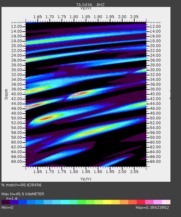
Q43A New Douglas, IL, USA - Earthquake Result Viewer
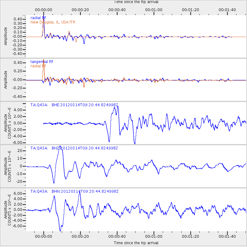
Earthquake location: Off East Coast Of Honshu, Japan
Earthquake latitude/longitude: 40.9/144.9
Earthquake time(UTC): 2012/03/14 (074) 09:08:35 GMT
Earthquake Depth: 12 km
Earthquake Magnitude: 6.7 MB, 6.9 MS, 6.9 MW, 7.0 MW
Earthquake Catalog/Contributor: WHDF/NEIC
Network: TA USArray Transportable Network (new EarthScope stations)
Station: Q43A New Douglas, IL, USA
Lat/Lon: 38.94 N/89.70 W
Elevation: 202 m
Distance: 86.2 deg
Az: 39.599 deg
Baz: 321.707 deg
Ray Param: 0.044207066
Estimated Moho Depth: 45.5 km
Estimated Crust Vp/Vs: 1.60
Assumed Crust Vp: 6.444 km/s
Estimated Crust Vs: 4.027 km/s
Estimated Crust Poisson's Ratio: 0.18
Radial Match: 98.629456 %
Radial Bump: 337
Transverse Match: 91.61502 %
Transverse Bump: 400
SOD ConfigId: 440406
Insert Time: 2012-05-25 23:05:35.234 +0000
GWidth: 2.5
Max Bumps: 400
Tol: 0.001

Signal To Noise

ChannelStoNSTALTA
TA:Q43A: :BHZ:20120314T09:20:44.824998Z19.7568022.8504458E-61.4427668E-7
TA:Q43A: :BHN:20120314T09:20:44.824998Z8.0738067.182829E-78.89646E-8
TA:Q43A: :BHE:20120314T09:20:44.824998Z4.88701447.0514665E-71.4428987E-7
Arrivals
Ps4.3 SECOND
PpPs18 SECOND
PsPs/PpSs22 SECOND