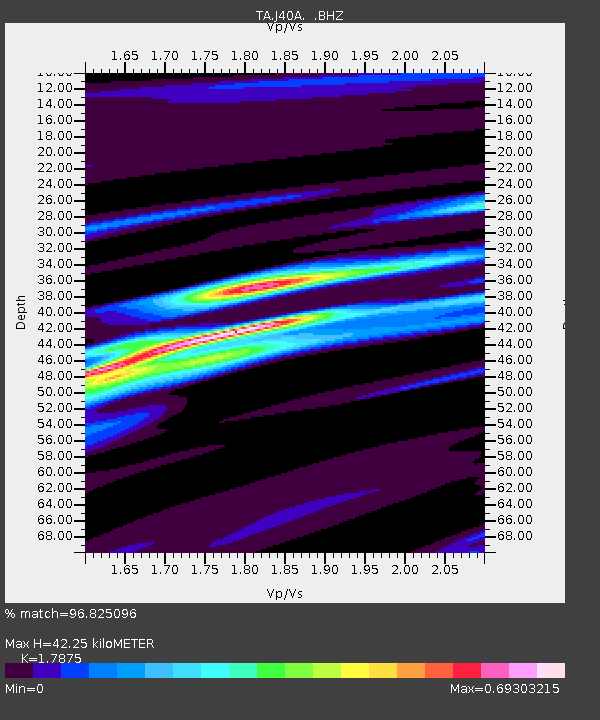
J40A Soldiers Grove, WI, USA - Earthquake Result Viewer

Earthquake location: Off East Coast Of Honshu, Japan
Earthquake latitude/longitude: 40.9/144.9
Earthquake time(UTC): 2012/03/14 (074) 09:08:35 GMT
Earthquake Depth: 12 km
Earthquake Magnitude: 6.7 MB, 6.9 MS, 6.9 MW, 7.0 MW
Earthquake Catalog/Contributor: WHDF/NEIC
Network: TA USArray Transportable Network (new EarthScope stations)
Station: J40A Soldiers Grove, WI, USA
Lat/Lon: 43.40 N/90.74 W
Elevation: 353 m
Distance: 82.3 deg
Az: 37.416 deg
Baz: 320.803 deg
Ray Param: 0.047013845
Estimated Moho Depth: 42.25 km
Estimated Crust Vp/Vs: 1.79
Assumed Crust Vp: 6.53 km/s
Estimated Crust Vs: 3.653 km/s
Estimated Crust Poisson's Ratio: 0.27
Radial Match: 96.825096 %
Radial Bump: 262
Transverse Match: 90.92831 %
Transverse Bump: 400
SOD ConfigId: 440406
Insert Time: 2012-05-25 23:06:35.818 +0000
GWidth: 2.5
Max Bumps: 400
Tol: 0.001

Signal To Noise

ChannelStoNSTALTA
TA:J40A: :BHZ:20120314T09:20:24.749985Z55.461445.896231E-61.0631225E-7
TA:J40A: :BHN:20120314T09:20:24.749985Z14.44111.3528962E-69.368374E-8
TA:J40A: :BHE:20120314T09:20:24.749985Z10.2277861.3149075E-61.2856228E-7
Arrivals
Ps5.2 SECOND
PpPs18 SECOND
PsPs/PpSs23 SECOND