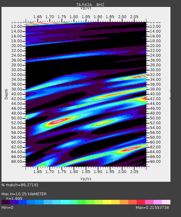
R42A Luebbering, MO, USA - Earthquake Result Viewer
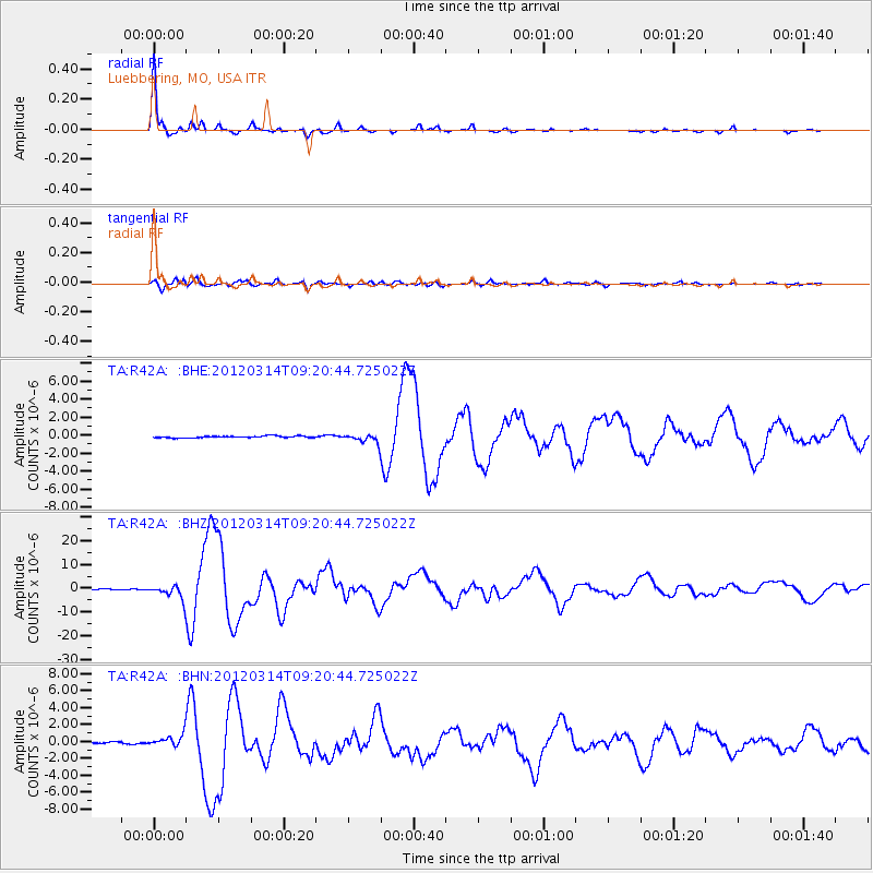
Earthquake location: Off East Coast Of Honshu, Japan
Earthquake latitude/longitude: 40.9/144.9
Earthquake time(UTC): 2012/03/14 (074) 09:08:35 GMT
Earthquake Depth: 12 km
Earthquake Magnitude: 6.7 MB, 6.9 MS, 6.9 MW, 7.0 MW
Earthquake Catalog/Contributor: WHDF/NEIC
Network: TA USArray Transportable Network (new EarthScope stations)
Station: R42A Luebbering, MO, USA
Lat/Lon: 38.28 N/90.79 W
Elevation: 218 m
Distance: 86.2 deg
Az: 40.683 deg
Baz: 321.098 deg
Ray Param: 0.04422114
Estimated Moho Depth: 10.25 km
Estimated Crust Vp/Vs: 1.66
Assumed Crust Vp: 6.498 km/s
Estimated Crust Vs: 3.902 km/s
Estimated Crust Poisson's Ratio: 0.22
Radial Match: 99.27191 %
Radial Bump: 188
Transverse Match: 94.97761 %
Transverse Bump: 400
SOD ConfigId: 440406
Insert Time: 2012-05-25 23:07:19.761 +0000
GWidth: 2.5
Max Bumps: 400
Tol: 0.001

Signal To Noise

ChannelStoNSTALTA
TA:R42A: :BHZ:20120314T09:20:44.725022Z27.6355932.9239193E-61.0580266E-7
TA:R42A: :BHN:20120314T09:20:44.725022Z4.8873296.5341857E-71.3369645E-7
TA:R42A: :BHE:20120314T09:20:44.725022Z5.0327264.8447276E-79.6264486E-8
Arrivals
Ps1.1 SECOND
PpPs4.1 SECOND
PsPs/PpSs5.2 SECOND