You are here: Home > Network List > G - GEOSCOPE Stations List
> Station INU Inuyama, Japan > Earthquake Result Viewer
INU Inuyama, Japan - Earthquake Result Viewer
| Earthquake location: |
Solomon Islands |
| Earthquake latitude/longitude: |
-7.0/155.0 |
| Earthquake time(UTC): |
2001/05/29 (149) 23:37:19 GMT |
| Earthquake Depth: |
14 km |
| Earthquake Magnitude: |
5.7 MB, 6.4 MS, 6.4 MW, 5.7 ME |
| Earthquake Catalog/Contributor: |
WHDF/NEIC |
|
| Network: |
G GEOSCOPE |
| Station: |
INU Inuyama, Japan |
| Lat/Lon: |
35.35 N/137.03 E |
| Elevation: |
132 m |
|
| Distance: |
45.4 deg |
| Az: |
339.224 deg |
| Baz: |
154.488 deg |
| Ray Param: |
0.07126897 |
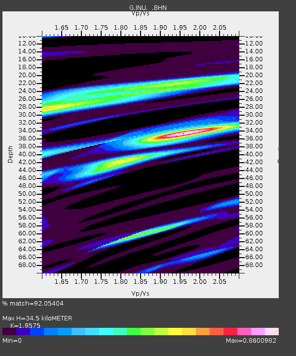
| Estimated Moho Depth: |
34.5 km |
| Estimated Crust Vp/Vs: |
1.96 |
| Assumed Crust Vp: |
6.461 km/s |
| Estimated Crust Vs: |
3.301 km/s |
| Estimated Crust Poisson's Ratio: |
0.32 |
|
| Radial Match: |
92.05404 % |
| Radial Bump: |
400 |
| Transverse Match: |
67.56163 % |
| Transverse Bump: |
400 |
| SOD ConfigId: |
4714 |
| Insert Time: |
2010-02-26 23:20:50.782 +0000 |
| GWidth: |
2.5 |
| Max Bumps: |
400 |
| Tol: |
0.001 |
|
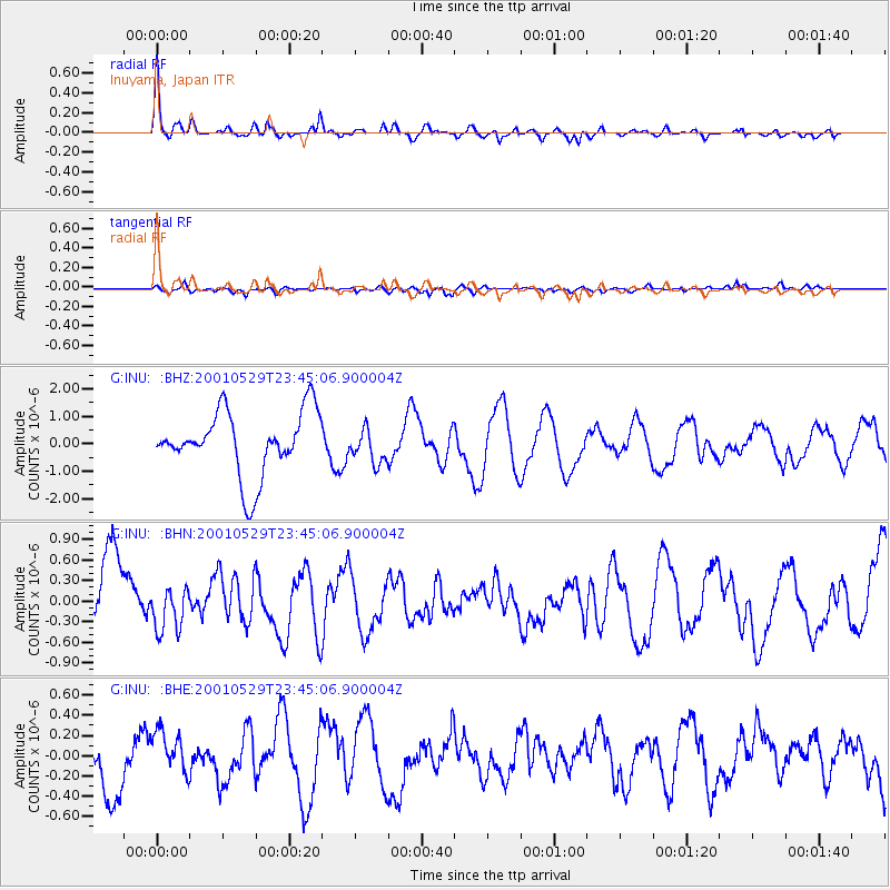
Signal To Noise
| Channel | StoN | STA | LTA |
| G:INU: :BHN:20010529T23:45:06.900004Z | 0.55547416 | 3.1786712E-7 | 5.7224463E-7 |
| G:INU: :BHE:20010529T23:45:06.900004Z | 0.87450165 | 2.5486486E-7 | 2.914401E-7 |
| G:INU: :BHZ:20010529T23:45:06.900004Z | 0.5355548 | 6.162549E-7 | 1.150685E-6 |
| Arrivals |
| Ps | 5.4 SECOND |
| PpPs | 15 SECOND |
| PsPs/PpSs | 20 SECOND |


