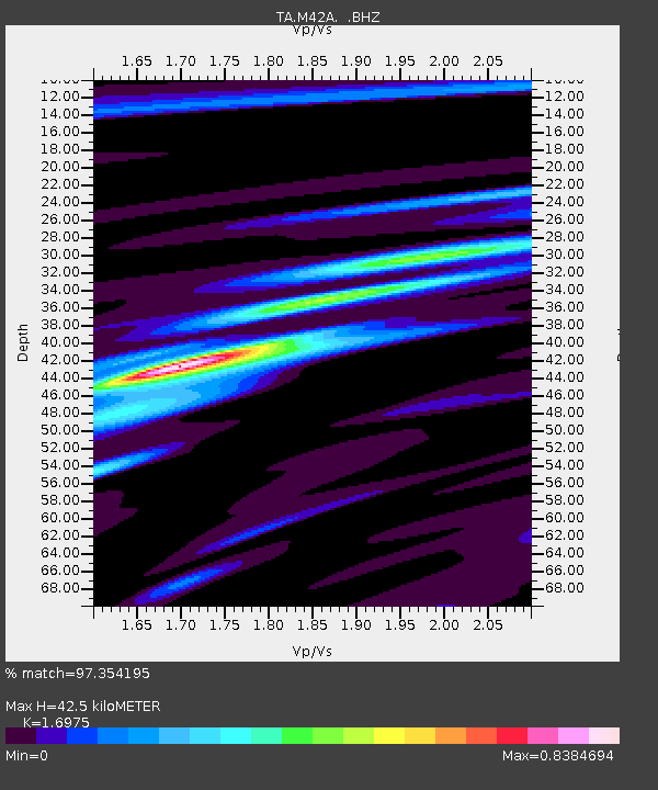
M42A Sheffield, IL, USA - Earthquake Result Viewer

Earthquake location: Off East Coast Of Honshu, Japan
Earthquake latitude/longitude: 40.9/144.9
Earthquake time(UTC): 2012/03/14 (074) 09:08:35 GMT
Earthquake Depth: 12 km
Earthquake Magnitude: 6.7 MB, 6.9 MS, 6.9 MW, 7.0 MW
Earthquake Catalog/Contributor: WHDF/NEIC
Network: TA USArray Transportable Network (new EarthScope stations)
Station: M42A Sheffield, IL, USA
Lat/Lon: 41.45 N/89.76 W
Elevation: 212 m
Distance: 84.2 deg
Az: 38.07 deg
Baz: 321.541 deg
Ray Param: 0.045634933
Estimated Moho Depth: 42.5 km
Estimated Crust Vp/Vs: 1.70
Assumed Crust Vp: 6.498 km/s
Estimated Crust Vs: 3.828 km/s
Estimated Crust Poisson's Ratio: 0.23
Radial Match: 97.354195 %
Radial Bump: 322
Transverse Match: 83.67815 %
Transverse Bump: 400
SOD ConfigId: 440406
Insert Time: 2012-05-25 23:07:32.959 +0000
GWidth: 2.5
Max Bumps: 400
Tol: 0.001

Signal To Noise

ChannelStoNSTALTA
TA:M42A: :BHZ:20120314T09:20:34.874985Z32.08346.265281E-61.9528109E-7
TA:M42A: :BHN:20120314T09:20:34.874985Z9.93215751.8724003E-61.88519E-7
TA:M42A: :BHE:20120314T09:20:34.874985Z9.13213351.3550236E-61.4837974E-7
Arrivals
Ps4.7 SECOND
PpPs17 SECOND
PsPs/PpSs22 SECOND