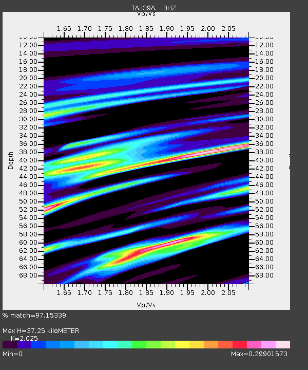
I39A Houston, MN, USA - Earthquake Result Viewer

Earthquake location: Off East Coast Of Honshu, Japan
Earthquake latitude/longitude: 40.9/144.9
Earthquake time(UTC): 2012/03/14 (074) 09:08:35 GMT
Earthquake Depth: 12 km
Earthquake Magnitude: 6.7 MB, 6.9 MS, 6.9 MW, 7.0 MW
Earthquake Catalog/Contributor: WHDF/NEIC
Network: TA USArray Transportable Network (new EarthScope stations)
Station: I39A Houston, MN, USA
Lat/Lon: 43.85 N/91.52 W
Elevation: 393 m
Distance: 81.5 deg
Az: 37.565 deg
Baz: 320.287 deg
Ray Param: 0.04751425
Estimated Moho Depth: 37.25 km
Estimated Crust Vp/Vs: 2.03
Assumed Crust Vp: 6.53 km/s
Estimated Crust Vs: 3.225 km/s
Estimated Crust Poisson's Ratio: 0.34
Radial Match: 97.15339 %
Radial Bump: 360
Transverse Match: 86.17268 %
Transverse Bump: 400
SOD ConfigId: 440406
Insert Time: 2012-05-25 23:09:05.327 +0000
GWidth: 2.5
Max Bumps: 400
Tol: 0.001

Signal To Noise

ChannelStoNSTALTA
TA:I39A: :BHZ:20120314T09:20:21.02501Z51.1925286.303302E-61.2312934E-7
TA:I39A: :BHN:20120314T09:20:21.02501Z5.84891561.6339133E-62.793532E-7
TA:I39A: :BHE:20120314T09:20:21.02501Z5.0303371.57122E-63.1234885E-7
Arrivals
Ps6.0 SECOND
PpPs17 SECOND
PsPs/PpSs23 SECOND