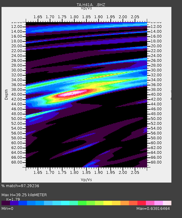
H41A Junction City, WI, USA - Earthquake Result Viewer
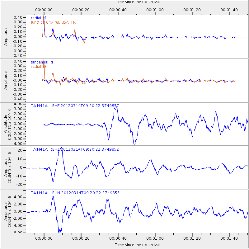
Earthquake location: Off East Coast Of Honshu, Japan
Earthquake latitude/longitude: 40.9/144.9
Earthquake time(UTC): 2012/03/14 (074) 09:08:35 GMT
Earthquake Depth: 12 km
Earthquake Magnitude: 6.7 MB, 6.9 MS, 6.9 MW, 7.0 MW
Earthquake Catalog/Contributor: WHDF/NEIC
Network: TA USArray Transportable Network (new EarthScope stations)
Station: H41A Junction City, WI, USA
Lat/Lon: 44.62 N/89.65 W
Elevation: 348 m
Distance: 81.8 deg
Az: 36.026 deg
Baz: 321.363 deg
Ray Param: 0.047332693
Estimated Moho Depth: 39.25 km
Estimated Crust Vp/Vs: 1.79
Assumed Crust Vp: 6.41 km/s
Estimated Crust Vs: 3.581 km/s
Estimated Crust Poisson's Ratio: 0.27
Radial Match: 97.29236 %
Radial Bump: 318
Transverse Match: 91.14008 %
Transverse Bump: 400
SOD ConfigId: 440406
Insert Time: 2012-05-25 23:09:09.999 +0000
GWidth: 2.5
Max Bumps: 400
Tol: 0.001

Signal To Noise

ChannelStoNSTALTA
TA:H41A: :BHZ:20120314T09:20:22.374985Z31.3511334.782984E-61.5256177E-7
TA:H41A: :BHN:20120314T09:20:22.374985Z12.8636861.364287E-61.06057236E-7
TA:H41A: :BHE:20120314T09:20:22.374985Z10.7681569.538677E-78.858227E-8
Arrivals
Ps5.0 SECOND
PpPs17 SECOND
PsPs/PpSs22 SECOND