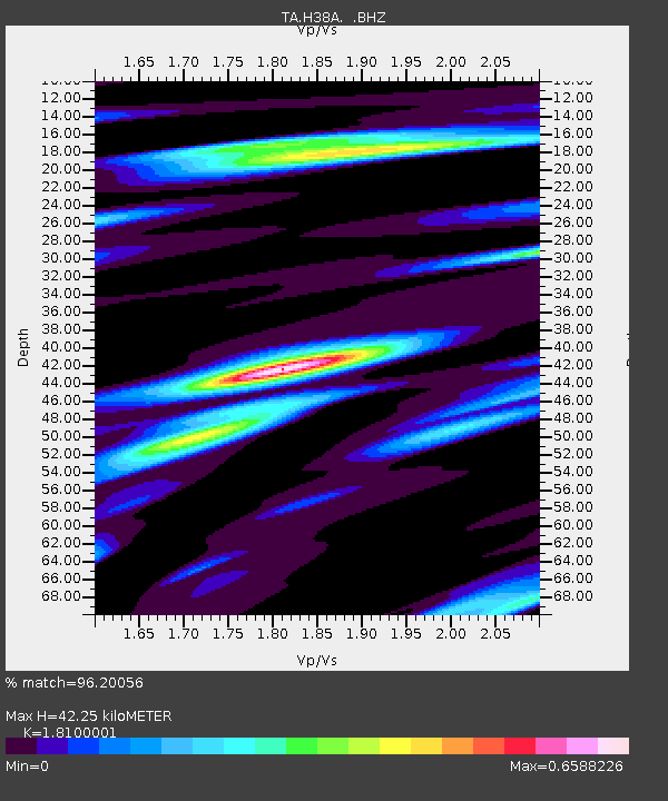
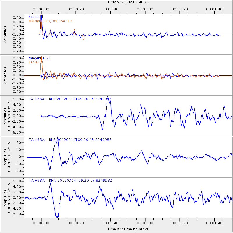
H38A Maiden Rock, WI, USA - Earthquake Result Viewer

Earthquake location: Off East Coast Of Honshu, Japan
Earthquake latitude/longitude: 40.9/144.9
Earthquake time(UTC): 2012/03/14 (074) 09:08:35 GMT
Earthquake Depth: 12 km
Earthquake Magnitude: 6.7 MB, 6.9 MS, 6.9 MW, 7.0 MW
Earthquake Catalog/Contributor: WHDF/NEIC
Network: TA USArray Transportable Network (new EarthScope stations)
Station: H38A Maiden Rock, WI, USA
Lat/Lon: 44.68 N/92.28 W
Elevation: 333 m
Distance: 80.6 deg
Az: 37.454 deg
Baz: 319.741 deg
Ray Param: 0.04819182
Estimated Moho Depth: 42.25 km
Estimated Crust Vp/Vs: 1.81
Assumed Crust Vp: 6.571 km/s
Estimated Crust Vs: 3.63 km/s
Estimated Crust Poisson's Ratio: 0.28
Radial Match: 96.20056 %
Radial Bump: 400
Transverse Match: 83.88499 %
Transverse Bump: 400
SOD ConfigId: 440406
Insert Time: 2012-05-25 23:09:22.738 +0000
GWidth: 2.5
Max Bumps: 400
Tol: 0.001

Signal To Noise

ChannelStoNSTALTA
TA:H38A: :BHZ:20120314T09:20:15.824998Z33.6804924.988848E-61.4812277E-7
TA:H38A: :BHN:20120314T09:20:15.824998Z6.86906241.2527762E-61.823795E-7
TA:H38A: :BHE:20120314T09:20:15.824998Z4.8137699.712493E-72.0176485E-7
Arrivals
Ps5.4 SECOND
PpPs18 SECOND
PsPs/PpSs23 SECOND