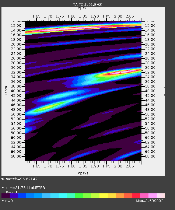
TOLK Tollok Lake Research Station, AK, USA - Earthquake Result Viewer

Earthquake location: Off East Coast Of Honshu, Japan
Earthquake latitude/longitude: 40.9/144.9
Earthquake time(UTC): 2012/03/14 (074) 09:08:35 GMT
Earthquake Depth: 12 km
Earthquake Magnitude: 6.7 MB, 6.9 MS, 6.9 MW, 7.0 MW
Earthquake Catalog/Contributor: WHDF/NEIC
Network: TA USArray Transportable Network (new EarthScope stations)
Station: TOLK Tollok Lake Research Station, AK, USA
Lat/Lon: 68.64 N/149.57 W
Elevation: 760 m
Distance: 43.8 deg
Az: 28.798 deg
Baz: 265.535 deg
Ray Param: 0.07232317
Estimated Moho Depth: 31.75 km
Estimated Crust Vp/Vs: 2.01
Assumed Crust Vp: 6.316 km/s
Estimated Crust Vs: 3.142 km/s
Estimated Crust Poisson's Ratio: 0.34
Radial Match: 95.62142 %
Radial Bump: 400
Transverse Match: 89.94474 %
Transverse Bump: 400
SOD ConfigId: 440406
Insert Time: 2012-05-25 23:09:42.348 +0000
GWidth: 2.5
Max Bumps: 400
Tol: 0.001

Signal To Noise

ChannelStoNSTALTA
TA:TOLK:01:BHZ:20120314T09:16:09.65001Z22.487963.0480523E-61.3554153E-7
TA:TOLK:01:BHN:20120314T09:16:09.65001Z4.19891644.9694387E-71.183505E-7
TA:TOLK:01:BHE:20120314T09:16:09.65001Z8.7048041.1803227E-61.3559439E-7
Arrivals
Ps5.4 SECOND
PpPs14 SECOND
PsPs/PpSs20 SECOND