F41A Wisconsin Rapids, WI, USA - Earthquake Result Viewer
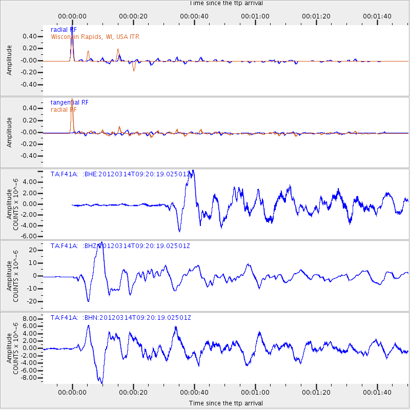
Earthquake location: Off East Coast Of Honshu, Japan
Earthquake latitude/longitude: 40.9/144.9
Earthquake time(UTC): 2012/03/14 (074) 09:08:35 GMT
Earthquake Depth: 12 km
Earthquake Magnitude: 6.7 MB, 6.9 MS, 6.9 MW, 7.0 MW
Earthquake Catalog/Contributor: WHDF/NEIC
Network: TA USArray Transportable Network (new EarthScope stations)
Station: F41A Wisconsin Rapids, WI, USA
Lat/Lon: 45.74 N/89.10 W
Elevation: 509 m
Distance: 81.2 deg
Az: 35.012 deg
Baz: 321.601 deg
Ray Param: 0.047779884
Estimated Moho Depth: 35.5 km
Estimated Crust Vp/Vs: 1.88
Assumed Crust Vp: 6.41 km/s
Estimated Crust Vs: 3.414 km/s
Estimated Crust Poisson's Ratio: 0.30
Radial Match: 98.77181 %
Radial Bump: 183
Transverse Match: 91.261856 %
Transverse Bump: 400
SOD ConfigId: 440406
Insert Time: 2012-05-25 23:10:51.543 +0000
GWidth: 2.5
Max Bumps: 400
Tol: 0.001

Signal To Noise

ChannelStoNSTALTA
TA:F41A: :BHZ:20120314T09:20:19.02501Z42.191724.117371E-69.758719E-8
TA:F41A: :BHN:20120314T09:20:19.02501Z10.6937861.337609E-61.2508283E-7
TA:F41A: :BHE:20120314T09:20:19.02501Z11.7850591.0767087E-69.136218E-8
Arrivals
Ps5.0 SECOND
PpPs16 SECOND
PsPs/PpSs21 SECOND