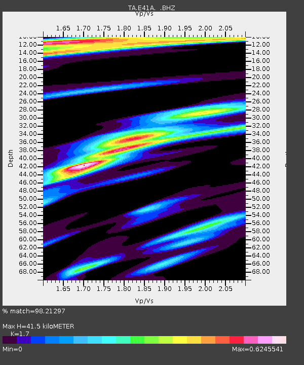
E41A Kenton, MI, USA - Earthquake Result Viewer
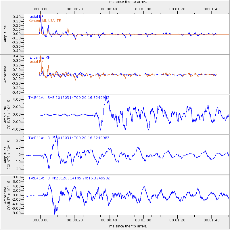
Earthquake location: Off East Coast Of Honshu, Japan
Earthquake latitude/longitude: 40.9/144.9
Earthquake time(UTC): 2012/03/14 (074) 09:08:35 GMT
Earthquake Depth: 12 km
Earthquake Magnitude: 6.7 MB, 6.9 MS, 6.9 MW, 7.0 MW
Earthquake Catalog/Contributor: WHDF/NEIC
Network: TA USArray Transportable Network (new EarthScope stations)
Station: E41A Kenton, MI, USA
Lat/Lon: 46.46 N/88.96 W
Elevation: 377 m
Distance: 80.6 deg
Az: 34.478 deg
Baz: 321.618 deg
Ray Param: 0.04812888
Estimated Moho Depth: 41.5 km
Estimated Crust Vp/Vs: 1.70
Assumed Crust Vp: 6.467 km/s
Estimated Crust Vs: 3.804 km/s
Estimated Crust Poisson's Ratio: 0.24
Radial Match: 98.21297 %
Radial Bump: 400
Transverse Match: 89.77345 %
Transverse Bump: 400
SOD ConfigId: 440406
Insert Time: 2012-05-25 23:11:17.305 +0000
GWidth: 2.5
Max Bumps: 400
Tol: 0.001

Signal To Noise

ChannelStoNSTALTA
TA:E41A: :BHZ:20120314T09:20:16.324998Z31.9881785.644923E-61.7646904E-7
TA:E41A: :BHN:20120314T09:20:16.324998Z9.6496381.1339463E-61.175118E-7
TA:E41A: :BHE:20120314T09:20:16.324998Z7.8338141.1132507E-61.4210839E-7
Arrivals
Ps4.6 SECOND
PpPs17 SECOND
PsPs/PpSs21 SECOND