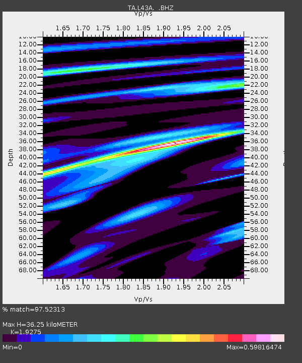
L43A Garden Prairie, IL, USA - Earthquake Result Viewer
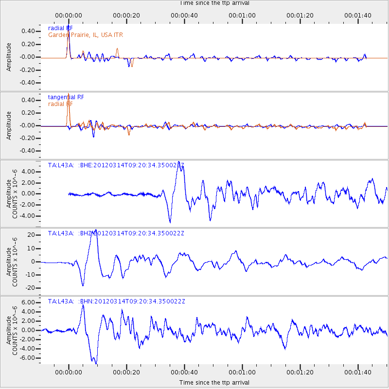
Earthquake location: Off East Coast Of Honshu, Japan
Earthquake latitude/longitude: 40.9/144.9
Earthquake time(UTC): 2012/03/14 (074) 09:08:35 GMT
Earthquake Depth: 12 km
Earthquake Magnitude: 6.7 MB, 6.9 MS, 6.9 MW, 7.0 MW
Earthquake Catalog/Contributor: WHDF/NEIC
Network: TA USArray Transportable Network (new EarthScope stations)
Station: L43A Garden Prairie, IL, USA
Lat/Lon: 42.18 N/88.74 W
Elevation: 266 m
Distance: 84.1 deg
Az: 37.018 deg
Baz: 322.109 deg
Ray Param: 0.04570557
Estimated Moho Depth: 36.25 km
Estimated Crust Vp/Vs: 1.93
Assumed Crust Vp: 6.571 km/s
Estimated Crust Vs: 3.409 km/s
Estimated Crust Poisson's Ratio: 0.32
Radial Match: 97.52313 %
Radial Bump: 400
Transverse Match: 87.39817 %
Transverse Bump: 400
SOD ConfigId: 440406
Insert Time: 2012-05-25 23:11:52.560 +0000
GWidth: 2.5
Max Bumps: 400
Tol: 0.001

Signal To Noise

ChannelStoNSTALTA
TA:L43A: :BHZ:20120314T09:20:34.350022Z36.9201165.5543887E-61.5044343E-7
TA:L43A: :BHN:20120314T09:20:34.350022Z9.9137661.673363E-61.6879187E-7
TA:L43A: :BHE:20120314T09:20:34.350022Z8.4684641.3327764E-61.5738112E-7
Arrivals
Ps5.2 SECOND
PpPs16 SECOND
PsPs/PpSs21 SECOND