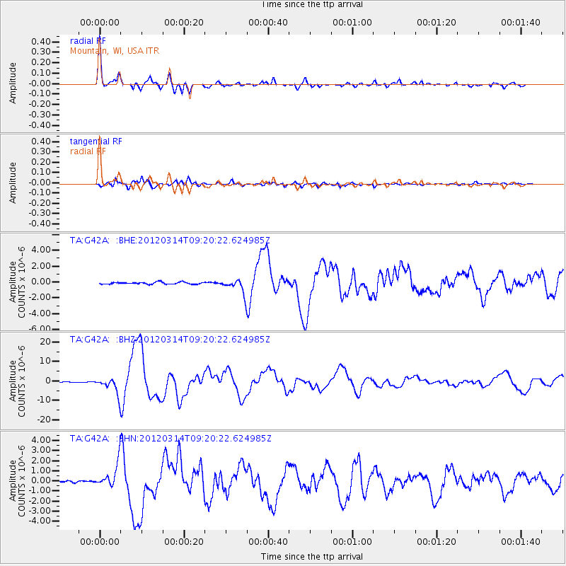
G42A Mountain, WI, USA - Earthquake Result Viewer
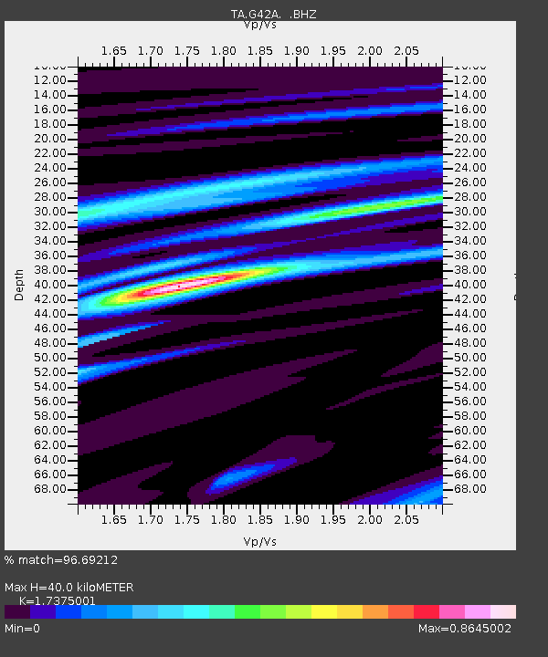
Earthquake location: Off East Coast Of Honshu, Japan
Earthquake latitude/longitude: 40.9/144.9
Earthquake time(UTC): 2012/03/14 (074) 09:08:35 GMT
Earthquake Depth: 12 km
Earthquake Magnitude: 6.7 MB, 6.9 MS, 6.9 MW, 7.0 MW
Earthquake Catalog/Contributor: WHDF/NEIC
Network: TA USArray Transportable Network (new EarthScope stations)
Station: G42A Mountain, WI, USA
Lat/Lon: 45.24 N/88.43 W
Elevation: 315 m
Distance: 81.8 deg
Az: 34.944 deg
Baz: 322.072 deg
Ray Param: 0.047298584
Estimated Moho Depth: 40.0 km
Estimated Crust Vp/Vs: 1.74
Assumed Crust Vp: 6.41 km/s
Estimated Crust Vs: 3.689 km/s
Estimated Crust Poisson's Ratio: 0.25
Radial Match: 96.69212 %
Radial Bump: 352
Transverse Match: 94.3895 %
Transverse Bump: 400
SOD ConfigId: 440406
Insert Time: 2012-05-25 23:13:01.239 +0000
GWidth: 2.5
Max Bumps: 400
Tol: 0.001

Signal To Noise

ChannelStoNSTALTA
TA:G42A: :BHZ:20120314T09:20:22.624985Z27.8217874.334153E-61.557827E-7
TA:G42A: :BHN:20120314T09:20:22.624985Z14.0449491.222696E-68.705593E-8
TA:G42A: :BHE:20120314T09:20:22.624985Z7.89241559.871105E-71.2507078E-7
Arrivals
Ps4.7 SECOND
PpPs17 SECOND
PsPs/PpSs21 SECOND