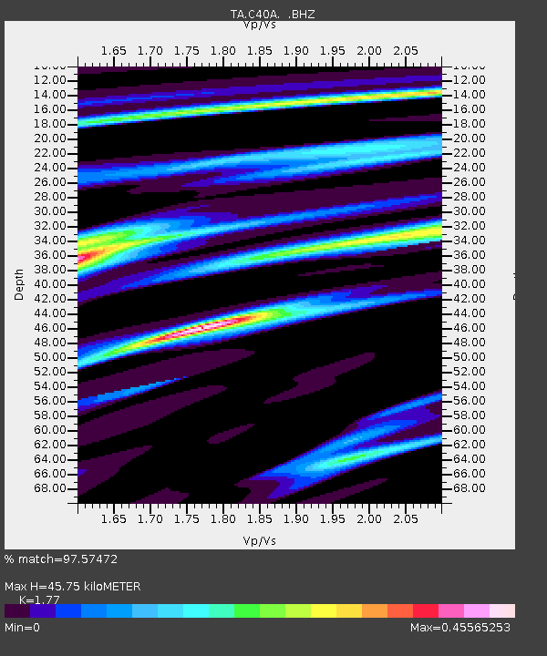
C40A Isle Royale National Park, MI, USA - Earthquake Result Viewer

Earthquake location: Off East Coast Of Honshu, Japan
Earthquake latitude/longitude: 40.9/144.9
Earthquake time(UTC): 2012/03/14 (074) 09:08:35 GMT
Earthquake Depth: 12 km
Earthquake Magnitude: 6.7 MB, 6.9 MS, 6.9 MW, 7.0 MW
Earthquake Catalog/Contributor: WHDF/NEIC
Network: TA USArray Transportable Network (new EarthScope stations)
Station: C40A Isle Royale National Park, MI, USA
Lat/Lon: 47.92 N/89.15 W
Elevation: 216 m
Distance: 79.4 deg
Az: 33.661 deg
Baz: 321.339 deg
Ray Param: 0.048959758
Estimated Moho Depth: 45.75 km
Estimated Crust Vp/Vs: 1.77
Assumed Crust Vp: 6.467 km/s
Estimated Crust Vs: 3.653 km/s
Estimated Crust Poisson's Ratio: 0.27
Radial Match: 97.57472 %
Radial Bump: 283
Transverse Match: 92.38603 %
Transverse Bump: 400
SOD ConfigId: 440406
Insert Time: 2012-05-25 23:13:14.795 +0000
GWidth: 2.5
Max Bumps: 400
Tol: 0.001

Signal To Noise

ChannelStoNSTALTA
TA:C40A: :BHZ:20120314T09:20:09.77501Z34.1852575.885171E-61.7215524E-7
TA:C40A: :BHN:20120314T09:20:09.77501Z13.1656741.5182212E-61.1531663E-7
TA:C40A: :BHE:20120314T09:20:09.77501Z11.86405851.3465453E-61.1349787E-7
Arrivals
Ps5.6 SECOND
PpPs19 SECOND
PsPs/PpSs25 SECOND