You are here: Home > Network List > TA - USArray Transportable Network (new EarthScope stations) Stations List
> Station I43A Langenfeld Brothers Farm, Elkhart Lake, WI, USA > Earthquake Result Viewer
I43A Langenfeld Brothers Farm, Elkhart Lake, WI, USA - Earthquake Result Viewer
| Earthquake location: |
Off East Coast Of Honshu, Japan |
| Earthquake latitude/longitude: |
40.9/144.9 |
| Earthquake time(UTC): |
2012/03/14 (074) 09:08:35 GMT |
| Earthquake Depth: |
12 km |
| Earthquake Magnitude: |
6.7 MB, 6.9 MS, 6.9 MW, 7.0 MW |
| Earthquake Catalog/Contributor: |
WHDF/NEIC |
|
| Network: |
TA USArray Transportable Network (new EarthScope stations) |
| Station: |
I43A Langenfeld Brothers Farm, Elkhart Lake, WI, USA |
| Lat/Lon: |
43.88 N/88.15 W |
| Elevation: |
299 m |
|
| Distance: |
83.0 deg |
| Az: |
35.622 deg |
| Baz: |
322.358 deg |
| Ray Param: |
0.046466317 |
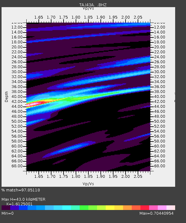
| Estimated Moho Depth: |
43.0 km |
| Estimated Crust Vp/Vs: |
1.61 |
| Assumed Crust Vp: |
6.571 km/s |
| Estimated Crust Vs: |
4.075 km/s |
| Estimated Crust Poisson's Ratio: |
0.19 |
|
| Radial Match: |
97.85118 % |
| Radial Bump: |
245 |
| Transverse Match: |
87.03389 % |
| Transverse Bump: |
400 |
| SOD ConfigId: |
440406 |
| Insert Time: |
2012-05-25 23:14:28.131 +0000 |
| GWidth: |
2.5 |
| Max Bumps: |
400 |
| Tol: |
0.001 |
|

Signal To Noise
| Channel | StoN | STA | LTA |
| TA:I43A: :BHZ:20120314T09:20:28.850022Z | 36.762093 | 4.400398E-6 | 1.1969935E-7 |
| TA:I43A: :BHN:20120314T09:20:28.850022Z | 8.021486 | 1.2571902E-6 | 1.5672785E-7 |
| TA:I43A: :BHE:20120314T09:20:28.850022Z | 8.710375 | 9.5224044E-7 | 1.09322556E-7 |
| Arrivals |
| Ps | 4.1 SECOND |
| PpPs | 17 SECOND |
| PsPs/PpSs | 21 SECOND |


