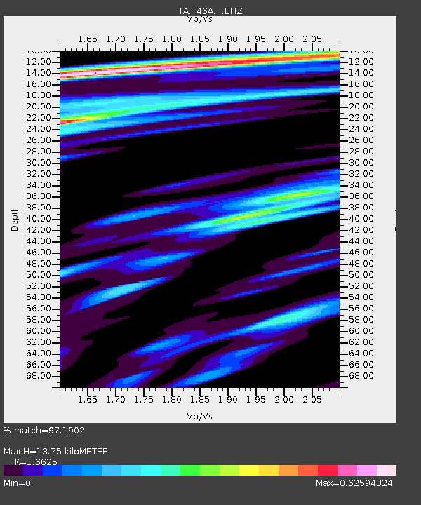
T46A Princeton, KY, USA - Earthquake Result Viewer
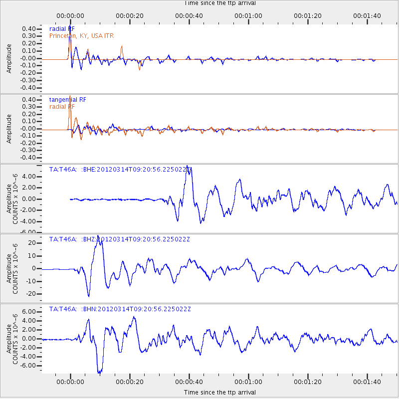
Earthquake location: Off East Coast Of Honshu, Japan
Earthquake latitude/longitude: 40.9/144.9
Earthquake time(UTC): 2012/03/14 (074) 09:08:35 GMT
Earthquake Depth: 12 km
Earthquake Magnitude: 6.7 MB, 6.9 MS, 6.9 MW, 7.0 MW
Earthquake Catalog/Contributor: WHDF/NEIC
Network: TA USArray Transportable Network (new EarthScope stations)
Station: T46A Princeton, KY, USA
Lat/Lon: 37.04 N/87.89 W
Elevation: 169 m
Distance: 88.6 deg
Az: 39.632 deg
Baz: 322.815 deg
Ray Param: 0.042472363
Estimated Moho Depth: 13.75 km
Estimated Crust Vp/Vs: 1.66
Assumed Crust Vp: 6.444 km/s
Estimated Crust Vs: 3.876 km/s
Estimated Crust Poisson's Ratio: 0.22
Radial Match: 97.1902 %
Radial Bump: 400
Transverse Match: 96.85869 %
Transverse Bump: 400
SOD ConfigId: 440406
Insert Time: 2012-05-25 23:15:56.387 +0000
GWidth: 2.5
Max Bumps: 400
Tol: 0.001

Signal To Noise

ChannelStoNSTALTA
TA:T46A: :BHZ:20120314T09:20:56.225022Z9.4192211.2983278E-61.3783813E-7
TA:T46A: :BHN:20120314T09:20:56.225022Z6.06836844.976452E-78.200642E-8
TA:T46A: :BHE:20120314T09:20:56.225022Z5.12933163.791401E-77.391608E-8
Arrivals
Ps1.4 SECOND
PpPs5.6 SECOND
PsPs/PpSs7.0 SECOND