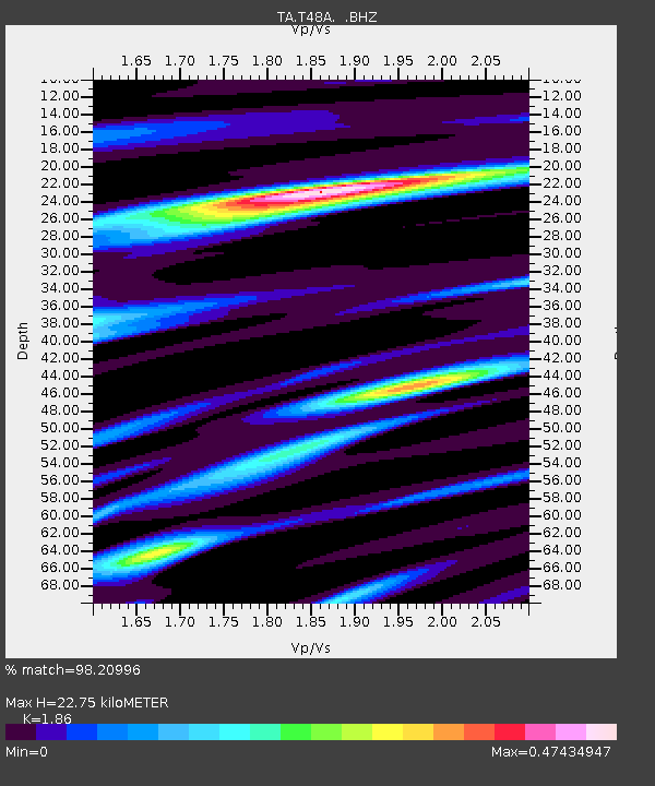
T48A Bowling Green, KY, USA - Earthquake Result Viewer
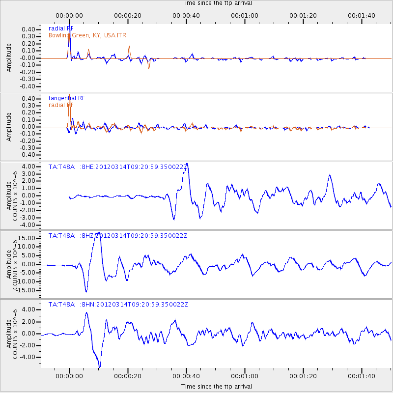
Earthquake location: Off East Coast Of Honshu, Japan
Earthquake latitude/longitude: 40.9/144.9
Earthquake time(UTC): 2012/03/14 (074) 09:08:35 GMT
Earthquake Depth: 12 km
Earthquake Magnitude: 6.7 MB, 6.9 MS, 6.9 MW, 7.0 MW
Earthquake Catalog/Contributor: WHDF/NEIC
Network: TA USArray Transportable Network (new EarthScope stations)
Station: T48A Bowling Green, KY, USA
Lat/Lon: 37.11 N/86.39 W
Elevation: 218 m
Distance: 89.3 deg
Az: 38.63 deg
Baz: 323.696 deg
Ray Param: 0.041983522
Estimated Moho Depth: 22.75 km
Estimated Crust Vp/Vs: 1.86
Assumed Crust Vp: 6.444 km/s
Estimated Crust Vs: 3.464 km/s
Estimated Crust Poisson's Ratio: 0.30
Radial Match: 98.20996 %
Radial Bump: 374
Transverse Match: 87.8089 %
Transverse Bump: 400
SOD ConfigId: 440406
Insert Time: 2012-05-25 23:16:09.035 +0000
GWidth: 2.5
Max Bumps: 400
Tol: 0.001

Signal To Noise

ChannelStoNSTALTA
TA:T48A: :BHZ:20120314T09:20:59.350022Z13.41955951.4296158E-61.0653225E-7
TA:T48A: :BHN:20120314T09:20:59.350022Z2.96624522.551256E-78.6009614E-8
TA:T48A: :BHE:20120314T09:20:59.350022Z3.06334473.8059449E-71.2424148E-7
Arrivals
Ps3.1 SECOND
PpPs9.9 SECOND
PsPs/PpSs13 SECOND