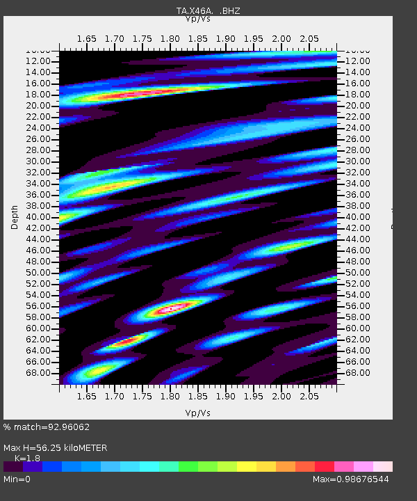
X46A Booneville, MS, USA - Earthquake Result Viewer
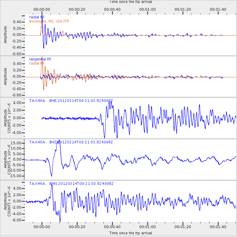
Earthquake location: Off East Coast Of Honshu, Japan
Earthquake latitude/longitude: 40.9/144.9
Earthquake time(UTC): 2012/03/14 (074) 09:08:35 GMT
Earthquake Depth: 12 km
Earthquake Magnitude: 6.7 MB, 6.9 MS, 6.9 MW, 7.0 MW
Earthquake Catalog/Contributor: WHDF/NEIC
Network: TA USArray Transportable Network (new EarthScope stations)
Station: X46A Booneville, MS, USA
Lat/Lon: 34.56 N/88.58 W
Elevation: 150 m
Distance: 90.2 deg
Az: 41.583 deg
Baz: 322.433 deg
Ray Param: 0.041688804
Estimated Moho Depth: 56.25 km
Estimated Crust Vp/Vs: 1.80
Assumed Crust Vp: 6.38 km/s
Estimated Crust Vs: 3.545 km/s
Estimated Crust Poisson's Ratio: 0.28
Radial Match: 92.96062 %
Radial Bump: 400
Transverse Match: 82.858475 %
Transverse Bump: 400
SOD ConfigId: 440406
Insert Time: 2012-05-25 23:16:34.974 +0000
GWidth: 2.5
Max Bumps: 400
Tol: 0.001

Signal To Noise

ChannelStoNSTALTA
TA:X46A: :BHZ:20120314T09:21:03.824998Z23.2185732.2010504E-69.479697E-8
TA:X46A: :BHN:20120314T09:21:03.824998Z6.16910936.8991426E-71.11833685E-7
TA:X46A: :BHE:20120314T09:21:03.824998Z5.22104177.222883E-71.383418E-7
Arrivals
Ps7.2 SECOND
PpPs24 SECOND
PsPs/PpSs31 SECOND