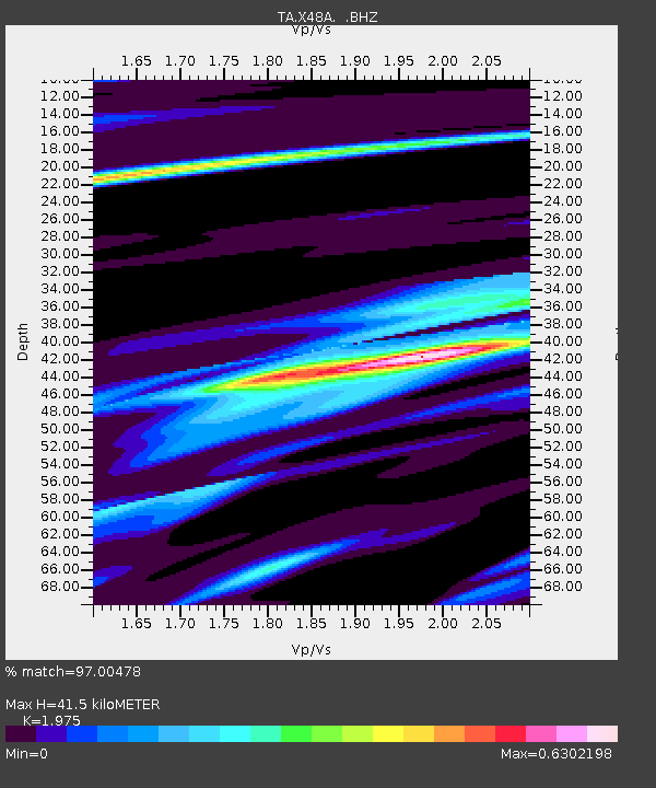
X48A Hartselle, AL, USA - Earthquake Result Viewer

Earthquake location: Off East Coast Of Honshu, Japan
Earthquake latitude/longitude: 40.9/144.9
Earthquake time(UTC): 2012/03/14 (074) 09:08:35 GMT
Earthquake Depth: 12 km
Earthquake Magnitude: 6.7 MB, 6.9 MS, 6.9 MW, 7.0 MW
Earthquake Catalog/Contributor: WHDF/NEIC
Network: TA USArray Transportable Network (new EarthScope stations)
Station: X48A Hartselle, AL, USA
Lat/Lon: 34.45 N/87.05 W
Elevation: 180 m
Distance: 91.1 deg
Az: 40.633 deg
Baz: 323.312 deg
Ray Param: 0.04162814
Estimated Moho Depth: 41.5 km
Estimated Crust Vp/Vs: 1.98
Assumed Crust Vp: 6.476 km/s
Estimated Crust Vs: 3.279 km/s
Estimated Crust Poisson's Ratio: 0.33
Radial Match: 97.00478 %
Radial Bump: 263
Transverse Match: 91.60058 %
Transverse Bump: 400
SOD ConfigId: 440406
Insert Time: 2012-05-25 23:17:00.340 +0000
GWidth: 2.5
Max Bumps: 400
Tol: 0.001

Signal To Noise

ChannelStoNSTALTA
TA:X48A: :BHZ:20120314T09:21:07.77501Z21.6127592.5880306E-61.1974551E-7
TA:X48A: :BHN:20120314T09:21:07.77501Z8.1768485.784717E-77.0745074E-8
TA:X48A: :BHE:20120314T09:21:07.77501Z6.34887746.311142E-79.9405625E-8
Arrivals
Ps6.4 SECOND
PpPs19 SECOND
PsPs/PpSs25 SECOND