V46A Holladay, TN, USA - Earthquake Result Viewer
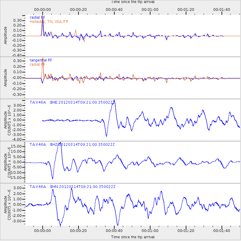
Earthquake location: Off East Coast Of Honshu, Japan
Earthquake latitude/longitude: 40.9/144.9
Earthquake time(UTC): 2012/03/14 (074) 09:08:35 GMT
Earthquake Depth: 12 km
Earthquake Magnitude: 6.7 MB, 6.9 MS, 6.9 MW, 7.0 MW
Earthquake Catalog/Contributor: WHDF/NEIC
Network: TA USArray Transportable Network (new EarthScope stations)
Station: V46A Holladay, TN, USA
Lat/Lon: 35.80 N/88.12 W
Elevation: 162 m
Distance: 89.5 deg
Az: 40.525 deg
Baz: 322.698 deg
Ray Param: 0.041828003
Estimated Moho Depth: 35.5 km
Estimated Crust Vp/Vs: 1.81
Assumed Crust Vp: 6.38 km/s
Estimated Crust Vs: 3.525 km/s
Estimated Crust Poisson's Ratio: 0.28
Radial Match: 98.314316 %
Radial Bump: 374
Transverse Match: 92.616615 %
Transverse Bump: 400
SOD ConfigId: 440406
Insert Time: 2012-05-25 23:17:25.030 +0000
GWidth: 2.5
Max Bumps: 400
Tol: 0.001

Signal To Noise

ChannelStoNSTALTA
TA:V46A: :BHZ:20120314T09:21:00.350022Z20.6668031.955683E-69.46292E-8
TA:V46A: :BHN:20120314T09:21:00.350022Z2.314632.8447042E-71.2290103E-7
TA:V46A: :BHE:20120314T09:21:00.350022Z4.55477573.370233E-77.399339E-8
Arrivals
Ps4.6 SECOND
PpPs15 SECOND
PsPs/PpSs20 SECOND