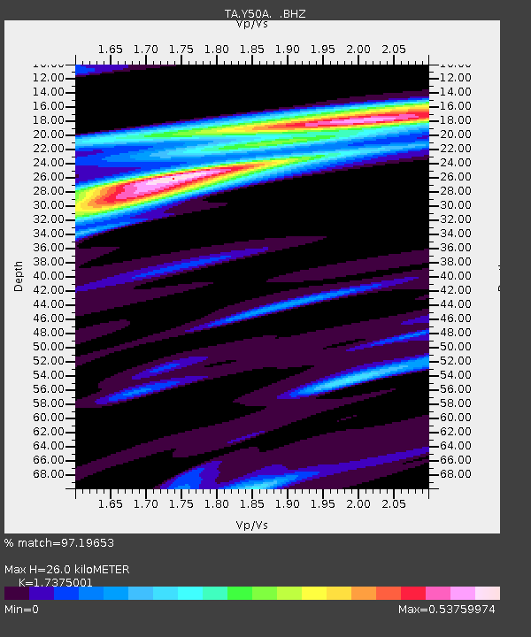
Y50A Piedmont, AL, USA - Earthquake Result Viewer
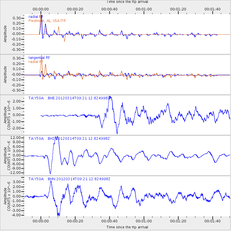
Earthquake location: Off East Coast Of Honshu, Japan
Earthquake latitude/longitude: 40.9/144.9
Earthquake time(UTC): 2012/03/14 (074) 09:08:35 GMT
Earthquake Depth: 12 km
Earthquake Magnitude: 6.7 MB, 6.9 MS, 6.9 MW, 7.0 MW
Earthquake Catalog/Contributor: WHDF/NEIC
Network: TA USArray Transportable Network (new EarthScope stations)
Station: Y50A Piedmont, AL, USA
Lat/Lon: 33.89 N/85.73 W
Elevation: 248 m
Distance: 92.2 deg
Az: 40.088 deg
Baz: 324.06 deg
Ray Param: 0.04149936
Estimated Moho Depth: 26.0 km
Estimated Crust Vp/Vs: 1.74
Assumed Crust Vp: 6.719 km/s
Estimated Crust Vs: 3.867 km/s
Estimated Crust Poisson's Ratio: 0.25
Radial Match: 97.19653 %
Radial Bump: 260
Transverse Match: 90.348946 %
Transverse Bump: 400
SOD ConfigId: 440406
Insert Time: 2012-05-25 23:17:36.226 +0000
GWidth: 2.5
Max Bumps: 400
Tol: 0.001

Signal To Noise

ChannelStoNSTALTA
TA:Y50A: :BHZ:20120314T09:21:12.824998Z12.354921.6485433E-61.3343212E-7
TA:Y50A: :BHN:20120314T09:21:12.824998Z3.30125362.7288252E-78.266028E-8
TA:Y50A: :BHE:20120314T09:21:12.824998Z4.1973632.6581867E-76.332992E-8
Arrivals
Ps2.9 SECOND
PpPs10 SECOND
PsPs/PpSs13 SECOND