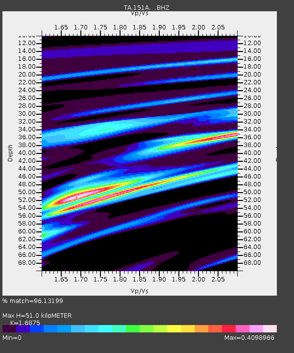
151A Opelika, AL, USA - Earthquake Result Viewer
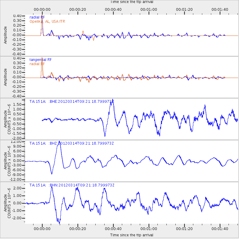
Earthquake location: Off East Coast Of Honshu, Japan
Earthquake latitude/longitude: 40.9/144.9
Earthquake time(UTC): 2012/03/14 (074) 09:08:35 GMT
Earthquake Depth: 12 km
Earthquake Magnitude: 6.7 MB, 6.9 MS, 6.9 MW, 7.0 MW
Earthquake Catalog/Contributor: WHDF/NEIC
Network: TA USArray Transportable Network (new EarthScope stations)
Station: 151A Opelika, AL, USA
Lat/Lon: 32.53 N/85.33 W
Elevation: 211 m
Distance: 93.5 deg
Az: 40.608 deg
Baz: 324.256 deg
Ray Param: 0.041254517
Estimated Moho Depth: 51.0 km
Estimated Crust Vp/Vs: 1.69
Assumed Crust Vp: 6.719 km/s
Estimated Crust Vs: 3.982 km/s
Estimated Crust Poisson's Ratio: 0.23
Radial Match: 96.13199 %
Radial Bump: 400
Transverse Match: 81.93547 %
Transverse Bump: 400
SOD ConfigId: 440406
Insert Time: 2012-05-25 23:18:24.852 +0000
GWidth: 2.5
Max Bumps: 400
Tol: 0.001

Signal To Noise

ChannelStoNSTALTA
TA:151A: :BHZ:20120314T09:21:18.799973Z12.7371291.5100632E-61.18556E-7
TA:151A: :BHN:20120314T09:21:18.799973Z6.3876553.8231747E-75.985256E-8
TA:151A: :BHE:20120314T09:21:18.799973Z4.1997053.2655237E-77.775602E-8
Arrivals
Ps5.3 SECOND
PpPs20 SECOND
PsPs/PpSs25 SECOND