452A Marianna, FL, USA - Earthquake Result Viewer
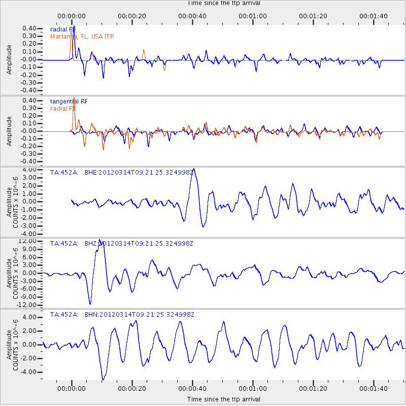
Earthquake location: Off East Coast Of Honshu, Japan
Earthquake latitude/longitude: 40.9/144.9
Earthquake time(UTC): 2012/03/14 (074) 09:08:35 GMT
Earthquake Depth: 12 km
Earthquake Magnitude: 6.7 MB, 6.9 MS, 6.9 MW, 7.0 MW
Earthquake Catalog/Contributor: WHDF/NEIC
Network: TA USArray Transportable Network (new EarthScope stations)
Station: 452A Marianna, FL, USA
Lat/Lon: 30.85 N/85.18 W
Elevation: 35 m
Distance: 94.9 deg
Az: 41.488 deg
Baz: 324.267 deg
Ray Param: 0.040925585
Estimated Moho Depth: 17.75 km
Estimated Crust Vp/Vs: 1.93
Assumed Crust Vp: 6.347 km/s
Estimated Crust Vs: 3.293 km/s
Estimated Crust Poisson's Ratio: 0.32
Radial Match: 95.80516 %
Radial Bump: 337
Transverse Match: 90.453674 %
Transverse Bump: 352
SOD ConfigId: 440406
Insert Time: 2012-05-25 23:18:49.488 +0000
GWidth: 2.5
Max Bumps: 400
Tol: 0.001

Signal To Noise

ChannelStoNSTALTA
TA:452A: :BHZ:20120314T09:21:25.324998Z2.51247126.8919434E-72.7430934E-7
TA:452A: :BHN:20120314T09:21:25.324998Z1.62216953.511052E-72.1644175E-7
TA:452A: :BHE:20120314T09:21:25.324998Z0.942072032.5460534E-72.70261E-7
Arrivals
Ps2.6 SECOND
PpPs8.0 SECOND
PsPs/PpSs11 SECOND