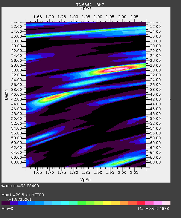
656A Willston, FL, USA - Earthquake Result Viewer

Earthquake location: Off East Coast Of Honshu, Japan
Earthquake latitude/longitude: 40.9/144.9
Earthquake time(UTC): 2012/03/14 (074) 09:08:35 GMT
Earthquake Depth: 12 km
Earthquake Magnitude: 6.7 MB, 6.9 MS, 6.9 MW, 7.0 MW
Earthquake Catalog/Contributor: WHDF/NEIC
Network: TA USArray Transportable Network (new EarthScope stations)
Station: 656A Willston, FL, USA
Lat/Lon: 29.37 N/82.53 W
Elevation: 28 m
Distance: 97.4 deg
Az: 40.449 deg
Baz: 325.701 deg
Ray Param: 0.04021865
Estimated Moho Depth: 29.5 km
Estimated Crust Vp/Vs: 1.97
Assumed Crust Vp: 5.989 km/s
Estimated Crust Vs: 3.036 km/s
Estimated Crust Poisson's Ratio: 0.33
Radial Match: 93.88408 %
Radial Bump: 400
Transverse Match: 75.45812 %
Transverse Bump: 400
SOD ConfigId: 440406
Insert Time: 2012-05-25 23:19:23.104 +0000
GWidth: 2.5
Max Bumps: 400
Tol: 0.001

Signal To Noise

ChannelStoNSTALTA
TA:656A: :BHZ:20120314T09:21:36.699998Z3.19323595.2438264E-71.642167E-7
TA:656A: :BHN:20120314T09:21:36.699998Z1.15556741.9304639E-71.6705766E-7
TA:656A: :BHE:20120314T09:21:36.699998Z0.694405851.1430116E-71.6460281E-7
Arrivals
Ps4.9 SECOND
PpPs14 SECOND
PsPs/PpSs19 SECOND