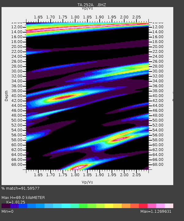
252A Lumpkin, GA, USA - Earthquake Result Viewer
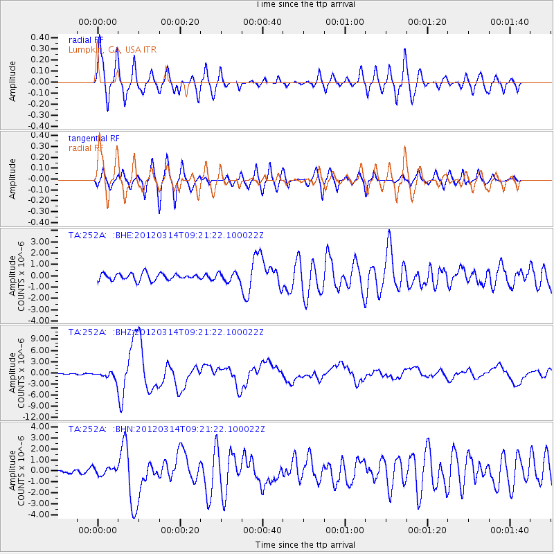
Earthquake location: Off East Coast Of Honshu, Japan
Earthquake latitude/longitude: 40.9/144.9
Earthquake time(UTC): 2012/03/14 (074) 09:08:35 GMT
Earthquake Depth: 12 km
Earthquake Magnitude: 6.7 MB, 6.9 MS, 6.9 MW, 7.0 MW
Earthquake Catalog/Contributor: WHDF/NEIC
Network: TA USArray Transportable Network (new EarthScope stations)
Station: 252A Lumpkin, GA, USA
Lat/Lon: 32.00 N/84.74 W
Elevation: 142 m
Distance: 94.2 deg
Az: 40.508 deg
Baz: 324.577 deg
Ray Param: 0.04110131
Estimated Moho Depth: 69.0 km
Estimated Crust Vp/Vs: 1.81
Assumed Crust Vp: 6.347 km/s
Estimated Crust Vs: 3.502 km/s
Estimated Crust Poisson's Ratio: 0.28
Radial Match: 91.59577 %
Radial Bump: 400
Transverse Match: 86.591866 %
Transverse Bump: 400
SOD ConfigId: 440406
Insert Time: 2012-05-25 23:19:48.655 +0000
GWidth: 2.5
Max Bumps: 400
Tol: 0.001

Signal To Noise

ChannelStoNSTALTA
TA:252A: :BHZ:20120314T09:21:22.100022Z6.41620971.1085867E-61.7277907E-7
TA:252A: :BHN:20120314T09:21:22.100022Z0.84278633.2334216E-73.8365854E-7
TA:252A: :BHE:20120314T09:21:22.100022Z1.29494233.8597673E-72.980648E-7
Arrivals
Ps9.0 SECOND
PpPs30 SECOND
PsPs/PpSs39 SECOND