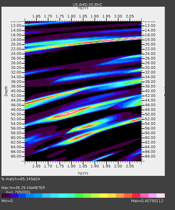
AHID Auburn Hatchery, Idaho, USA - Earthquake Result Viewer

Earthquake location: Off East Coast Of Honshu, Japan
Earthquake latitude/longitude: 40.9/144.9
Earthquake time(UTC): 2012/03/14 (074) 09:08:35 GMT
Earthquake Depth: 12 km
Earthquake Magnitude: 6.7 MB, 6.9 MS, 6.9 MW, 7.0 MW
Earthquake Catalog/Contributor: WHDF/NEIC
Network: US United States National Seismic Network
Station: AHID Auburn Hatchery, Idaho, USA
Lat/Lon: 42.77 N/111.10 W
Elevation: 1960 m
Distance: 72.2 deg
Az: 48.66 deg
Baz: 309.376 deg
Ray Param: 0.053846844
Estimated Moho Depth: 49.25 km
Estimated Crust Vp/Vs: 1.79
Assumed Crust Vp: 6.207 km/s
Estimated Crust Vs: 3.477 km/s
Estimated Crust Poisson's Ratio: 0.27
Radial Match: 95.345604 %
Radial Bump: 400
Transverse Match: 84.1891 %
Transverse Bump: 400
SOD ConfigId: 440406
Insert Time: 2012-05-25 23:20:24.932 +0000
GWidth: 2.5
Max Bumps: 400
Tol: 0.001

Signal To Noise

ChannelStoNSTALTA
US:AHID:00:BHZ:20120314T09:19:28.262986Z6.3231898.3801154E-71.3252989E-7
US:AHID:00:BHN:20120314T09:19:28.262986Z0.81443392.6464957E-73.2494913E-7
US:AHID:00:BHE:20120314T09:19:28.262986Z0.293738071.361378E-74.6346668E-7
Arrivals
Ps6.4 SECOND
PpPs21 SECOND
PsPs/PpSs28 SECOND