INU Inuyama, Japan - Earthquake Result Viewer
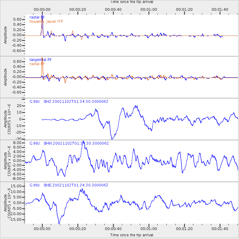
Earthquake location: Northern Sumatra, Indonesia
Earthquake latitude/longitude: 2.8/96.1
Earthquake time(UTC): 2002/11/02 (306) 01:26:10 GMT
Earthquake Depth: 30 km
Earthquake Magnitude: 6.2 MB, 7.6 MS, 7.4 MW, 7.4 MW
Earthquake Catalog/Contributor: WHDF/NEIC
Network: G GEOSCOPE
Station: INU Inuyama, Japan
Lat/Lon: 35.35 N/137.03 E
Elevation: 132 m
Distance: 49.8 deg
Az: 44.503 deg
Baz: 238.919 deg
Ray Param: 0.06839105
Estimated Moho Depth: 42.25 km
Estimated Crust Vp/Vs: 1.76
Assumed Crust Vp: 6.461 km/s
Estimated Crust Vs: 3.666 km/s
Estimated Crust Poisson's Ratio: 0.26
Radial Match: 94.015564 %
Radial Bump: 400
Transverse Match: 73.26726 %
Transverse Bump: 400
SOD ConfigId: 4714
Insert Time: 2010-02-26 23:21:37.739 +0000
GWidth: 2.5
Max Bumps: 400
Tol: 0.001

Signal To Noise

ChannelStoNSTALTA
G:INU: :BHN:20021102T01:34:30.300006Z3.2828772.6097002E-67.9494305E-7
G:INU: :BHE:20021102T01:34:30.300006Z8.4614065.0124654E-65.923916E-7
G:INU: :BHZ:20021102T01:34:30.300006Z9.5587629.643517E-61.0088668E-6
Arrivals
Ps5.3 SECOND
PpPs17 SECOND
PsPs/PpSs22 SECOND