You are here: Home > Network List > TA - USArray Transportable Network (new EarthScope stations) Stations List
> Station V40A Witts Springs, AR, USA > Earthquake Result Viewer
V40A Witts Springs, AR, USA - Earthquake Result Viewer
| Earthquake location: |
Off East Coast Of Honshu, Japan |
| Earthquake latitude/longitude: |
40.8/144.8 |
| Earthquake time(UTC): |
2012/03/14 (074) 10:49:24 GMT |
| Earthquake Depth: |
10 km |
| Earthquake Magnitude: |
5.8 MB, 6.1 MW |
| Earthquake Catalog/Contributor: |
WHDF/NEIC |
|
| Network: |
TA USArray Transportable Network (new EarthScope stations) |
| Station: |
V40A Witts Springs, AR, USA |
| Lat/Lon: |
35.80 N/92.82 W |
| Elevation: |
570 m |
|
| Distance: |
87.2 deg |
| Az: |
43.394 deg |
| Baz: |
320.074 deg |
| Ray Param: |
0.043461658 |
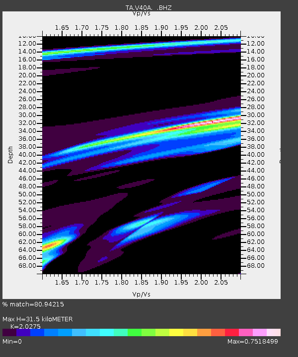
| Estimated Moho Depth: |
31.5 km |
| Estimated Crust Vp/Vs: |
2.03 |
| Assumed Crust Vp: |
6.498 km/s |
| Estimated Crust Vs: |
3.205 km/s |
| Estimated Crust Poisson's Ratio: |
0.34 |
|
| Radial Match: |
80.94215 % |
| Radial Bump: |
400 |
| Transverse Match: |
65.22943 % |
| Transverse Bump: |
381 |
| SOD ConfigId: |
440406 |
| Insert Time: |
2012-05-25 23:42:37.394 +0000 |
| GWidth: |
2.5 |
| Max Bumps: |
400 |
| Tol: |
0.001 |
|
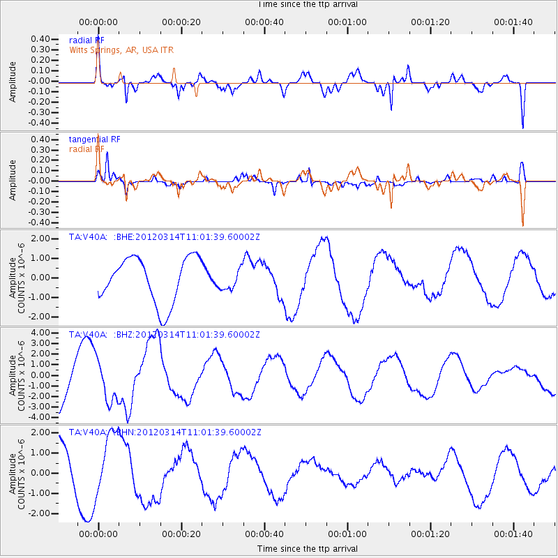
Signal To Noise
| Channel | StoN | STA | LTA |
| TA:V40A: :BHZ:20120314T11:01:39.60002Z | 0.94410384 | 1.9277106E-6 | 2.041842E-6 |
| TA:V40A: :BHN:20120314T11:01:39.60002Z | 1.4792669 | 1.565128E-6 | 1.0580429E-6 |
| TA:V40A: :BHE:20120314T11:01:39.60002Z | 0.4553116 | 5.3220657E-7 | 1.1688843E-6 |
| Arrivals |
| Ps | 5.1 SECOND |
| PpPs | 14 SECOND |
| PsPs/PpSs | 19 SECOND |


